Moubray Bay
Die Moubray Bay ist eine Bucht an der Borchgrevink-Küste des ostantarktischen Viktorialands. Sie liegt zwischen Kap Roget am Südende der Adare-Halbinsel und Kap Hallett an der Nordspitze der Hallett-Halbinsel.
| Moubray Bay | ||
|---|---|---|
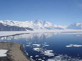
 Blick vom Kap Hallett über den südwestlichen Abschnitt der Moubray Bay zum Mount Herschel Blick vom Kap Hallett über den südwestlichen Abschnitt der Moubray Bay zum Mount Herschel | ||
| Gewässer | Rossmeer | |
| Landmasse | Viktorialand, Ostantarktika | |
| Geographische Lage | 72° 11′ 0″ S, 170° 15′ 0″ O | |
| ||
| Inseln | Hedgehog Island | |
| Zuflüsse | Burnette-Gletscher, Honeycomb-Gletscher, Ironside-Gletscher, Moubray-Gletscher, Moubray-Piedmont-Gletscher | |
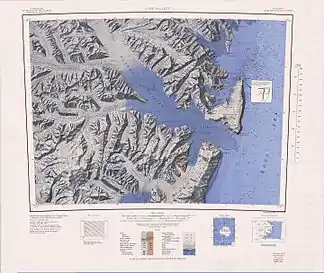
 Topografische Karte mit der Moubray Bay (rechts oben) Topografische Karte mit der Moubray Bay (rechts oben) | ||
Der britische Polarforscher James Clark Ross entdeckte sie 1841 bei seiner Antarktisexpedition (1839–1843). Ross benannte die Bucht nach George Henry Moubray (1810–1887), diensthabender Verwalter auf dem Forschungsschiff HMS Terror.
Weblinks
- Moubray Bay im Geographic Names Information System des United States Geological Survey (englisch)
- Moubray Bay auf geographic.org (englisch)
This article is issued from Wikipedia. The text is licensed under Creative Commons - Attribution - Sharealike. The authors of the article are listed here. Additional terms may apply for the media files, click on images to show image meta data.
