Kap Roget
Das Kap Roget ist das steile und felsige Südkap der Adare-Halbinsel, das die Nordseite der Einfahrt zur Moubray Bay an der Borchgrevink-Küste des antarktischen Viktorialands markiert.
| Kap Roget | ||
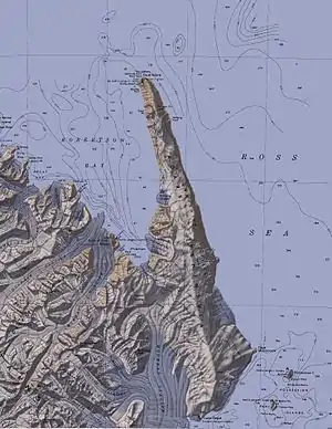 Kap Roget am südlichen Ende der Adare-Halbinsel | ||
| Geographische Lage | ||
| ||
| Koordinaten | 71° 59′ S, 170° 37′ O | |
| Lage | Viktorialand, Ostantarktika | |
| Küste | Borchgrevink-Küste | |
| Gewässer | Rossmeer | |
| Gewässer 2 | Moubray Bay | |

Entdeckt wurde es 1841 vom britischen Polarforscher James Clark Ross bei dessen Antarktisexpedition (1839–1843). Ross benannte es nach dem Lexikographen Peter Mark Roget (1779–1869), damaliger Sekretär der Royal Society. Am Kap ist eine Kolonie von Kaiserpinguinen beheimatet.
Weblinks
- Cape Roget im Geographic Names Information System des United States Geological Survey (englisch)
- Cape Roget auf geographic.org (englisch)
This article is issued from Wikipedia. The text is licensed under Creative Commons - Attribution - Sharealike. The authors of the article are listed here. Additional terms may apply for the media files, click on images to show image meta data.