Mont Durand
Der Mont Durand / Arbenhorn ist ein 3713 m ü. M. hoher Berg im Schweizer Kanton Wallis und liegt zwischen Zermatt im Mattertal und Zinal im Val d’Anniviers. Der Gipfel liegt westlich des Ober Gabelhorns. Der Mont Durand / Arbenhorn ist Teil der Sprachgrenze und einer der wenigen Berge in der Schweiz, die auf den amtlichen Landkarten des Bundesamts für Landestopografie Swisstopo zweisprachig benannt sind.
| Mont Durand / Arbenhorn | ||
|---|---|---|
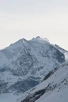
Blick vom Corne de Sorebois auf die Nordwand des Mont Durand / Arbenhorn. | ||
| Höhe | 3713 m ü. M. | |
| Lage | Kanton Wallis, Schweiz | |
| Gebirge | Walliser Alpen, Weisshorngruppe | |
| Dominanz | 0,95 km → Ober Gabelhorn | |
| Schartenhöhe | 169 m ↓ Arbenjoch | |
| Koordinaten | 616405 / 98045 | |
| ||
Weblinks
.jpg.webp)
Panoramaaufnahme des Zinalgletschers im Val d'Anniviers. Im Hintergrund die Gipfel (v. l. n. r.) von Besso (3.668 m), Trifthorn (3.728 m), Wellenkuppe (3.903 m), Ober Gabelhorn (4.068 m), Mont Durand Arbenhorn (3.712 m) und Grand Cornier (3.961 m).
This article is issued from Wikipedia. The text is licensed under Creative Commons - Attribution - Sharealike. The authors of the article are listed here. Additional terms may apply for the media files, click on images to show image meta data.