Moanumayanat
Moanumayanat (Muhanuhujanat) ist eine der indonesischen Kei-Inseln.
| Moanumayanat | ||
|---|---|---|
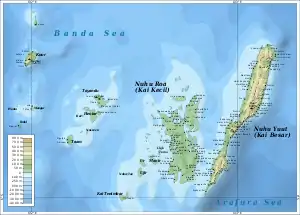 Moanumayanat liegt vor der Insel Duroa, nördlich der Kei-Hauptinseln Kei Dullah und Kei Kecil | ||
| Gewässer | Bandasee, Arafurasee, Seramsee | |
| Inselgruppe | Kei-Inseln | |
| Geographische Lage | 5° 33′ S, 132° 43′ O | |
| ||
Geographie
Moanumayanat ist der größeren Insel Duroa vorgelagert, nördlich der Hauptinseln der Gruppe Kei Dullah und Kei Kecil. Moanumayanat gehört zum Subdistrikt (Kecamatan) Pulau Dullah Utara des Regierungsbezirks (Kabupaten) der Südostmolukken (Maluku Tenggara). Dieser gehört zur indonesischen Provinz Maluku.[1]
This article is issued from Wikipedia. The text is licensed under Creative Commons - Attribution - Sharealike. The authors of the article are listed here. Additional terms may apply for the media files, click on images to show image meta data.