Maris Pacifici
Maris Pacifici (Descriptio Maris Pacifici) war die erste gedruckte Karte des Pazifik.
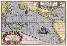
Die Karte wurde von Abraham Ortelius 1589 gezeichnet. Die Karte basiert auf der Karte Amerikas von Frans Hogenberg aus dem gleichen Jahr und auf der Beschreibung des Vaz Dourado von Japan aus dem Jahre 1568.[1]
Siehe auch
This article is issued from Wikipedia. The text is licensed under Creative Commons - Attribution - Sharealike. The authors of the article are listed here. Additional terms may apply for the media files, click on images to show image meta data.