Marble Point
Der Marble Point (englisch für Marmorspitze) ist eine Landspitze an der Scott-Küste des ostantarktischen Viktorialands. Sie ragt rund 5 km nördlich des Kap Bernacchi in den McMurdo-Sund hinein und markiert die nördliche Begrenzung der Bernacchi-Bucht.
| Marble Point | ||
 Marble Point (1957) | ||
| Geographische Lage | ||
| ||
| Koordinaten | 77° 26′ S, 163° 50′ O | |
| Lage | Viktorialand, Ostantarktika | |
| Küste | Scott-Küste | |
| Gewässer | McMurdo-Sund | |
| Gewässer 2 | Bernacchi-Bucht | |
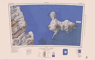
 Topographisches Kartenblatt Ross Island 1:250.000 mit Marble Point | ||
Teilnehmer der Nimrod-Expedition (1907–1909) unter der Leitung des britischen Polarforschers Ernest Shackleton kartierten sie und benannten sie nach dem dort gefundenen Marmor.
Weblinks
Commons: Marble Point – Sammlung von Bildern, Videos und Audiodateien
- Marble Point im Geographic Names Information System des United States Geological Survey (englisch)
- Marble Point auf geographic.org (englisch)
- Marble Point. In: Kenneth J. Bertrand und Fred G. Alberts, Geographic names of Antarctica, U.S. Govt. Print. Off., Washington 1956, S. 202–203 (englisch)
This article is issued from Wikipedia. The text is licensed under Creative Commons - Attribution - Sharealike. The authors of the article are listed here. Additional terms may apply for the media files, click on images to show image meta data.
