Liste der Gebirgspässe in Namibia

Dies ist eine Liste der Gebirgspässe in Namibia.

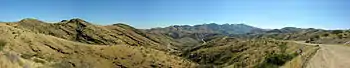
Der Gamsberg-Pass von der Hauptstraße C26 aus gesehen

Die meisten Gebirgspässe in Namibia liegen innerhalb von Gebirgszügen der Großen Randstufe und werden durch Straßen erschlossen. Die Große Randstufe verläuft in Namibia von Nord nach Süd und bildet mit Ausnahme der Randstufenlücke östlich von Swakopmund eine durchgehende Berglandschaft.

Liste

NamePass-
Höhe
Max.
Steigung
Berg/GebirgeStraßevon / nachRegionGeografische Koordinaten
Bosua-Pass1861 m20 %Witwatersberg/KhomashochlandSwakopmund / Curt von François-FesteErongo/Khomas!477.3097115515.971889522° 41′ 25″ S, 015° 58′ 19″ O
Gamsberg-Pass1494 m11 %Gamsberg/HakosbergeRostock / GöllschauKhomas!476.7666705516.250000523° 14′ 00″ S, 016° 15′ 00″ O
Gaub-Pass0755 m06 %Kuiseb-CanyonWalvis Bay / SolitaireKhomas!476.5194005515.764221523° 28′ 50″ S, 015° 45′ 51″ O
Grootberg-Pass1645 mGrootbergD2620Palmwag / KamanjabKunene!480.1666705514.133330519° 50′ 00″ S, 014° 08′ 00″ O
Joubert-Pass1600 m18 %JoubertbergeOpuwo / SesfonteinKunene!480.6210035513.871981519° 22′ 44″ S, 013° 52′ 19″ O
Kuiseb-Pass0872 m11 %Kuiseb-CanyonWalvis Bay / SolitaireErongo!476.6979005515.775411523° 18′ 08″ S, 015° 46′ 31″ O
Kupferberg-Pass2050 m08 %Kupferberg/KhomashochlandGöllschau / WindhoekKhomas!477.2703615516.937486522° 43′ 47″ S, 016° 56′ 15″ O
Otavi-Tsumeb-Pass1478 m07 %OtavibergeOtavi / TsumebOtjozondjupa/Oshikoto!480.6571075517.648335519° 20′ 34″ S, 017° 38′ 54″ O
Remhoogte-Pass2030 m10 %RemhoogtebergeSolitaire / RehobothKhomas!476.0295005516.260639523° 58′ 14″ S, 016° 15′ 38″ O
Robbie’s-Pass1283 mJoubertbergeOpuwo / SesfonteinKunene!481.3500005513.533330518° 39′ 00″ S, 013° 32′ 00″ O
Spreetshoogte-Pass1676 m22 %RantbergeD1275Solitaire / RehobothKhomas!476.3666705516.183330523° 38′ 00″ S, 016° 11′ 00″ O
Tsaris-Pass (Tsaris-Hoogte Pass)1630 m06 %TsarisbergeSesriem / MaltahöheHardap!475.0710065516.419475524° 55′ 44″ S, 016° 25′ 10″ O
Us-Pass (Us-Hoogte Pass)1812 m10 %HakosbergeD1982Walvisbaai / WindhoekKhomas!477.0388895516.516667522° 57′ 40″ S, 016° 31′ 00″ O
Van Zyl’s Pass948 m25 %OtjihipabergeD3703Okahorohombo / OpuwoKunene!482.3666705512.700000517° 38′ 00″ S, 012° 42′ 00″ O

Siehe auch

Commons: Gebirgspässe in Namibia – Sammlung von Bildern, Videos und Audiodateien
This article is issued from Wikipedia. The text is licensed under Creative Commons - Attribution - Sharealike. The authors of the article are listed here. Additional terms may apply for the media files, click on images to show image meta data.