Liste der Einträge im National Register of Historic Places im Wyoming County (New York)
Diese Liste der Einträge im National Register of Historic Places in Wyoming County, New York enthält alle bis zum Stichtag ausgewiesenen Anwesen und Distrikte, die im Wyoming County in New York in das National Register of Historic Places aufgenommen wurden.
- Stand: 21. April 2017
Liste der Einträge
| [1] | Name | Bild | Eintragsdatum | Lage | Ort | Beschreibung |
|---|---|---|---|---|---|---|
| 1 | Arcade and Attica Railroad | 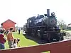 Arcade and Attica Railroad |
17. Nov. 1980 ID-Nr. 80002797 |
Railroad Right of way von Arcade nach North Java 42° 34′ 24″ N, 78° 25′ 22″ W |
North Java | |
| 2 | Arcade Center Farm | 15. Apr. 2004 ID-Nr. 04000290 |
7298 NY 98 42° 32′ 38″ N, 78° 24′ 12″ W |
Arcade | ||
| 3 | Attica Market and Main Historic District | 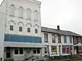 Attica Market and Main Historic District |
1. Mai 2013 ID-Nr. 13000225 |
2-28 & 19-45 Market St., 2-10 & 21-39 Main St. 42° 51′ 54,7″ N, 78° 17′ 4,8″ W |
Attica | |
| 4 | Brick Presbyterian Church |  Brick Presbyterian Church |
3. Okt. 2007 ID-Nr. 07001042 |
6 Church St. 42° 43′ 15″ N, 78° 0′ 4,7″ W |
Perry | |
| 5 | Epworth Hall | 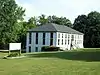 Epworth Hall |
6. Apr. 2000 ID-Nr. 00000350 |
Perry Ave. 42° 41′ 53″ N, 78° 1′ 16″ W |
Perry | |
| 6 | Exchange Street Historic District | 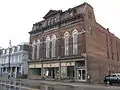 Exchange Street Historic District |
21. Nov. 2012 ID-Nr. 12000962 |
15-48 Exchange St. & Erie RR Depot 42° 51′ 47,6″ N, 78° 16′ 49,7″ W |
Attica | |
| 7 | First Free Will Baptist Church of Pike | 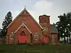 First Free Will Baptist Church of Pike |
27. Juni 2012 ID-Nr. 12000369 |
72 Main St. 42° 33′ 16,6″ N, 78° 9′ 21″ W |
Pike | |
| 8 | First Methodist Episcopal Church of Perry |  First Methodist Episcopal Church of Perry |
28. Sep. 2006 ID-Nr. 06000880 |
35 Covington St. 42° 43′ 10″ N, 78° 0′ 18″ W |
Perry | |
| 9 | First Universalist Church of Portageville | 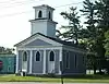 First Universalist Church of Portageville |
19. Feb. 2008 ID-Nr. 08000040 |
E. Koy Rd. at NY 19A 42° 34′ 4″ N, 78° 2′ 43″ W |
Portageville | |
| 10 | Bryant Fleming House | 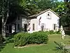 Bryant Fleming House |
14. Okt. 2009 ID-Nr. 09000838 |
1024 Tower Road 42° 49′ 52,4″ N, 78° 5′ 30,7″ W |
Wyoming | |
| 11 | Seth M. Gates House | 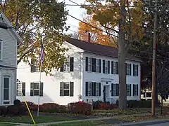 Seth M. Gates House |
21. Feb. 1992 ID-Nr. 92000031 |
15 Perry Ave. 42° 44′ 26″ N, 78° 8′ 6″ W |
Warsaw | |
| 12 | Java School No. 1 | 21. Juni 2001 ID-Nr. 01000672 |
NY 78 42° 40′ 26″ N, 78° 26′ 11″ W |
Java Village | ||
| 13 | Letchworth State Park |  Letchworth State Park |
4. Nov. 2005 ID-Nr. 03000718 |
Genesee River Gorge zwischen Portageville und Mt. Morris 42° 38′ 5″ N, 77° 59′ 0″ W |
Castile | |
| 14 | Middlebury Academy | 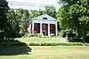 Middlebury Academy |
17. Jan. 1973 ID-Nr. 73001293 |
22 S. Academy St. 42° 49′ 39″ N, 78° 5′ 23″ W |
Wyoming | |
| 15 | Monument Circle Historic District | 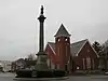 Monument Circle Historic District weitere Bilder |
11. Mai 1992 ID-Nr. 92000447 |
grob entlang der E. Court St. zwischen N. Main St. und Park St. sowie die angrenzenden Teile von Main und Park St. 42° 44′ 35″ N, 78° 7′ 53″ W |
Warsaw | |
| 16 | Perry Downtown Historic District | 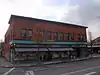 Perry Downtown Historic District |
16. Apr. 2012 ID-Nr. 12000212 |
N. & S. Main, Covington, & Lake Sts., Borden Ave. 42° 43′ 6,3″ N, 78° 0′ 7,4″ W |
Perry | |
| 17 | Barna C. Roup House | 10. Aug. 2015 ID-Nr. 15000519 |
38 Borden Ave. 42° 43′ 2,4″ N, 78° 0′ 11,9″ W |
Perry | 1898 im Queen Anne Style errichtetes Haus eines örtlich bekannten Rechtsanwaltes aus der Zeit des großen Wachstums des Villages | |
| 18 | Silver Lake Institute Historic District | 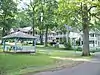 Silver Lake Institute Historic District |
19. Sep. 1985 ID-Nr. 85002442 |
grob begrenzt durch Wesley, Embury, Thompson, Haven, Lakeside und Lakeview Aves. 42° 41′ 56″ N, 78° 1′ 20″ W |
Silver Lake | |
| 19 | Augustus A. Smith House |  Augustus A. Smith House |
27. Juni 2007 ID-Nr. 07000627 |
125 Main St. 42° 51′ 44″ N, 78° 16′ 42″ W |
Attica | |
| 20 | Trinity Church |  Trinity Church |
18. März 1980 ID-Nr. 80002798 |
W. Buffalo St. 42° 44′ 23″ N, 78° 8′ 3″ W |
Warsaw | |
| 21 | US Post Office-Attica | 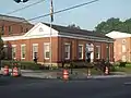 US Post Office-Attica |
17. Nov. 1988 ID-Nr. 88002453 |
76 Main St. 42° 51′ 49″ N, 78° 16′ 51″ W |
Attica | |
| 22 | US Post Office-Warsaw | 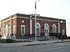 US Post Office-Warsaw weitere Bilder |
11. Mai 1989 ID-Nr. 88002441 |
35 S. Main St. 42° 44′ 22″ N, 78° 7′ 59″ W |
Warsaw | |
| 23 | Warsaw Academy | 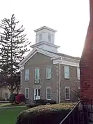 Warsaw Academy |
3. Jan. 1980 ID-Nr. 80002799 |
73 S. Main St. 42° 44′ 19″ N, 78° 7′ 58″ W |
Warsaw | |
| 24 | Warsaw Downtown Historic District | 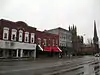 Warsaw Downtown Historic District |
21. Nov. 2012 ID-Nr. 12000963 |
N. & S. Main zwischen Frank & Brooklyn Sts. 42° 44′ 21,9″ N, 78° 7′ 57,3″ W |
Warsaw | |
| 25 | Orator F. Woodward Cottage | 22. Aug. 2016 ID-Nr. 16000559 |
3931 Thompson Ave. 42° 41′ 54,8″ N, 78° 1′ 10,8″ W |
Silver Lake | 1894 erbautes Ferienhaus des Jell-O-Erfinders, das später als Gästehaus für methodistische Prediger genutzt wurde, die das Silver Lake Institute besuchten | |
| 26 | Wyoming Village Historic District | 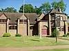 Wyoming Village Historic District |
27. Dez. 1974 ID-Nr. 74001326 |
NY 19 42° 49′ 37″ N, 78° 5′ 15″ W |
Wyoming |
Siehe auch
Anmerkungen
- Die Nummerierung in dieser Listenspalte ist an der vom National Park Service vorgelegten Reihenfolge der Einträge orientiert; die Farben unterscheiden verschiedene Schutzgebietstypen des National Park Systems mit landesweiter Bedeutung (z. B. National Historic Landmarks) von den sonstigen Einträgen im National Register of Historic Places.
National Register of Historic Places in New York
Albany City | Albany | Allegany | Bronx | Broome | Cattaraugus | Cayuga | Chautauqua | Chemung | Chenango | Clinton | Columbia | Cortland | Delaware | Dutchess | Erie | Essex | Franklin | Fulton | Genesee | Greene | Hamilton | Herkimer | Jefferson | Kings | Lewis | Livingston | Madison | Monroe | Montgomery | Nassau County | New York | Niagara | Oneida | Onondaga | Ontario | Orange | Orleans | Oswego | Otsego | Putnam | Queens | Rensselaer | Richmond | Rockland | Saratoga | Schenectady | Schoharie | Schuyler | Seneca | St. Lawrence | Steuben | Suffolk | Sullivan | Tioga | Tompkins | Ulster | Warren | Washington | Wayne | Westchester | Wyoming | Yates