Liste der Baudenkmale in Timaru
Die Liste der Baudenkmale in Timaru umfasst alle vom New Zealand Historic Places Trust (NZHPT) als „Historic Place“ oder „Historic Area“ eingestuften Baudenkmale und Flächendenkmale der neuseeländischen Stadt Timaru. Die Angaben stammen aus dem Register des NZHPT. Die Bezeichnungen der Baudenkmale orientieren sich an diesem Register. In die Liste werden auch bekannte Wahi Tapu (Area), kulturell und religiös bedeutsame Stätten und Gebiete der Māori, aufgenommen. Sie werden jedoch meist nicht publiziert.
| Bild | Bezeichnung | Ort | Anschrift | Beschreibung | Bauzeit | Eintrag | Nummer | Kat. |
|---|---|---|---|---|---|---|---|---|
 weitere Bilder |
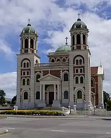
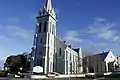
Basilica of the Sacred Heart | Timaru | Craigie Avenue Karte |
Kirche | 1911 | 2. April 1985 | 0325 | 1 |
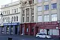
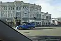
| Customhouse (Former) | Timaru | 2 Strathallan Street / Cains Terrace Karte |
ehem. Zollhaus, heute Restaurant | 1902 | 1. September 1983 | 0324 | 1 | |
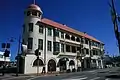
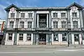
| Gladstone Board of Works Building | Timaru | Stafford Street Karte |
Verwaltungsgebäude | 1874 | 1. September 1983 | 0327 | 1 | |
| Headmaster's House | Timaru | Ecke 34 Arthur Street und Grey Road Karte |
Wohnhaus für den Direktor der Timaru Main School | 1877–1879 | 9. März 1985 | 2076 | 1 | |
 weitere Bilder |
Landing Service Building | Timaru | 2 George Street Karte |
ehemals Sitz eines Unternehmens zum Löschen der Ladung vor Timaru ankernden Schiffe | 1870–1876 | 6. September 1984 | 0326 | 1 |
 weitere Bilder |
St Mary's Church | Timaru | Ecke Church Street und Sophia Street Karte |
anglikanische Kirche | 1880 | 2. April 1985 | 0328 | 1 |
| Timaru Boys' High School Memorial Library | Timaru | 211 North Street Karte |
Schulbibliothek und Kriegsdenkmal | 1924 | 15. Juni 2001 | 7491 | 1 | |
| Timaru Milling Company Building | Timaru | 1 Mill Street Karte |
Industriedenkmal: Getreidemühle | 1882 | 28. Juni 1984 | 0239 | 1 | |
 weitere Bilder |
Aigantighe Art Gallery | Timaru | 47-53 Wai-iti Road Karte |
Kunstgalerie | 1910 | 23. Juni 1983 | 3152 | 2 |
 weitere Bilder |
Commercial Building | Timaru | 1 Cains Terrace and George Street Karte |
Büro- und Geschäftshaus | n.a. | 23. Juni 1983 | 3153 | 2 |
| Finch House | Timaru | 7 Park Lane Karte |
Wohnhaus | n.a. | 23. Juni 1983 | 3156 | 2 | |
| J.R. Bruce Flourmill (Former) | Timaru | Mill Street Karte |
Getreidemühle, ehemalige | n.a. | 23. Juni 1983 | 3157 | 2 | |
| Johnston's Menswear Building | Timaru | 218 Stafford Street Karte |
Laden | n.a. | 23. Juni 1983 | 3158 | 2 | |
| Old Bank Tavern | Timaru | 232 Stafford Street and Church Street Karte |
Gastwirtschaft | n.a. | 23. Juni 1983 | 3159 | 2 | |
| Old Mill Cabaret Ltd (Former Belford Mill) | Timaru | 2 North Street Karte |
Theater, früher Mühle | n.a. | 23. Juni 1983 | 3160 | 2 | |
| Public Trust Building | Timaru | 41 Sopia Street und Church Street Karte |
Verwaltungsgebäude | 1922 | 23. Juni 1983 | 3161 | 2 | |
| Royal Hotel | Timaru | 30 Cains Terrace Karte |
Hotel | n.a. | 23. Juni 1983 | 3162 | 2 | |
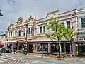
| Tekapo Buildings | Timaru | 259 Stafford Street Karte |
Laden | n.a. | 23. Juni 1983 | 3163 | 2 | |
| Theatre Royal | Timaru | 118-122 Stafford Street Karte |
Theater, früher Lagerhaus | 1877 | 19. September 1991 | 5393 | 2 | |
.jpg.webp) weitere Bilder |
Benvenue Memorial | Timaru | Perth Street, Post Office Triangle Karte |
Denkmal für die Opfer eines Schiffbruches | 1877 | 19. September 1991 | 2045 | 2 |
| Boer War Memorial | Timaru | Memorial Avenue Karte |
Denkmal für den Zweiten Burenkrieg | 1905 | 23. Juni 1983 | 2046 | 2 | |
 weitere Bilder |
Hay’s Building (Former) | Timaru | 229-241 Stafford Street Karte |
Büro- und Geschäftshaus | n.a. | 23. Juni 1983 | 2048 | 2 |
| Craighead School House | Timaru | 1 Wrights Avenue Karte |
Schule | 1875 | 23. Juni 1983 | 2051 | 2 | |
 weitere Bilder |
Hydro Grand Hotel | Timaru | 360 Stafford Street Karte |
Hotel; am 18. November 2017 abgerissen[1] | 1912 | 23. Juni 1983 | 2052 | 2 |
 weitere Bilder |
DB Dominion Hotel | Timaru | 334 Stafford Street Karte |
Hotel | n.a. | 23. Juni 1983 | 2053 | 2 |
| DB Grosvenor Hotel | Timaru | 26 Cains Terrace und Beswick Street Karte |
Hotel | n.a. | 23. Juni 1983 | 2054 | 2 | |
| D.C. Turnbull & Co. Limited Wool Store Buildings | Timaru | 1-13 Strathallan Street Karte |
Lagerhaus, Büro | n.a. | 23. Juni 1983 | 2055 | 2 | |
| Evans Atlas Flourmill Company Limited Building (Former) | Timaru | Turnbull Street Karte (ungenau) |
Mühle | 1888 | 23. Juni 1983 | 2056 | 2 | |
 weitere Bilder |
Farmers Trading Company Building | Timaru | 256 Stafford Street Karte |
Laden | 1902 | 23. Juni 1983 | 2057 | 2 |
| Government Life Building (Former) | Timaru | 148-154 Stafford Street und George Street Karte |
Versicherungsgebäude, heute Laden | n.a. | 23. Juni 1983 | 2058 | 2 | |
weitere Bilder |
James Meehan's Building | Timaru | 3-7 George Street Karte |
Geschäftshaus | 1913 | 23. Juni 1983 | 2062 | 2 |
| Linton | Timaru | Gleniti Road Karte |
Wohnhaus | n.a. | 23. Juni 1983 | 2063 | 2 | |
| Oakwood | Timaru | Gleniti Road Karte |
n.a. | 23. Juni 1983 | 2066 | 2 | ||
| O'Meeghan's Building (Formerly Choral Hall) | Timaru | 284-296 Stafford Street Karte |
Laden | n.a. | 23. Juni 1983 | 2067 | 2 | |
| Otumarama | Timaru | Pages Road | Wohnhaus | n.a. | 23. Juni 1983 | 2068 | 2 | |
weitere Bilder |
Pyne Gould Guinness Ltd Building | Timaru | 27-29 Strathallan Street Karte |
Bürogebäude | 1920 | 23. Juni 1983 | 2069 | 2 |
| T & G Building | Timaru | 199-209 Stafford Street Karte |
Büro- und Geschäftshaus | n.a. | 23. Juni 1983 | 2070 | 2 | |
| Tatawa | Timaru | Gleniti Road, Hadlow Karte |
Wohnhaus | n.a. | 23. Juni 1983 | 2071 | 2 | |
| The Croft Homestead | Timaru | 12 Park Lane Karte |
Wohnhaus | 1915 | 23. Juni 1983 | 2073 | 2 | |
| The Treasury Family Restaurant (Formerly National Bank Building) | Timaru | Stafford Street Karte |
Bank, heute gastronomisch genutzt | n.a. | 23. Juni 1983 | 2074 | 2 | |
 weitere Bilder |
Timaru City Council Offices and Former Public Library | Timaru | 2 King George Place Karte |
Verwaltungsgebäude | n.a. | 23. Juni 1983 | 2075 | 2 |
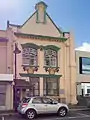 |
Shop-Offices (Former Vienna Cafe) | Timaru | 17 Beswick Street Karte |
Büro, früher Café | n.a. | 23. Juni 1983 | 2077 | 2 |
| World War One Memorial | Timaru | Queen Street und Memorial Avenue Karte |
Denkmal für den Ersten Weltkrieg | 1926 | 23. Juni 1983 | 2078 | 2 | |
| Blackett's Lighthouse | Timaru | Benvenue Avenue Karte |
Leuchtturm | 1877/1878 | 11. Dezember 2003 | 2044 | 2 | |
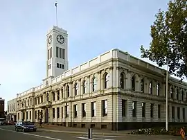
| Courthouse | Timaru | 14 North Street Karte |
Gerichtsgebäude | 1877/1878 | 11. Dezember 2003 | 2050 | 2 | |
| Gleniti Library | Timaru | Gleniti Road Karte |
Bibliothek | 1887 | 2. April 2004 | 2060 | 2 | |
| The Grange (Former) | Timaru | 1 Pages Road Karte |
Wohnhaus/Villa | 1893 | 2. April 2004 | 2072 | 2 | |
| Bank Street Church | Timaru | 38-40 Bank Street Karte |
Kirche | 1875 | 2. April 2004 | 3155 | 2 | |
 weitere Bilder |
Chalmers Church | Timaru | 4 Elizabeth Street Karte |
Kirche | 1903 | 17. Dezember 1993 | 7107 | 2 |
| Bluestone House | Timaru | 40 Maltby Avenue, Highfield Karte |
Wohnhaus | 1909 | 17. Dezember 1993 | 7116 | 2 | |
| Bluestone Reservoir Complex | Timaru | Brookfield Road Karte |
zwei Staubecken | 1874/1875 | 25. August 1995 | 7266 | 2 | |
| Brick Tunnel and Railway Siding | Timaru | Strathallan Street Karte |
Eisenbahntunnel aus Ziegelmauerwerk | 1900 | 19. April 1996 | 7307 | 2 | |
| Claremont Homestead | Timaru | Mt Horrible Road Karte |
Wohnhaus | 1890 | 24. April 1997 | 7379 | 2 | |
| Timaru Coast Defence Battery | Timaru | Bridge Road Karte |
Küstenverteidigungsanlage/Geschützbatterie | 1942 | 27. Juni 2008 | 7761 | 2 |
Weblinks
Einzelnachweise
- McPhee, Elena https://www.stuff.co.nz/timaru-herald/news/98998749/timaru-residents-take-photos-draw-the-105yearold-hydro-grand-hotel-ahead-of-demolition Timaru residents take photos, draw the 105-year-old Hydro Grand Hotel ahead of demolition Timaru Herald
This article is issued from Wikipedia. The text is licensed under Creative Commons - Attribution - Sharealike. The authors of the article are listed here. Additional terms may apply for the media files, click on images to show image meta data.