Lexington (Alabama)
Lexington ist eine Kleinstadt im Lauderdale County im Norden des US-Bundesstaates Alabama mit 840 Einwohnern (Volkszählung 2000). Die geographischen Koordinaten sind: 34°57'58" Nord, 87°22'22" West. Die Stadtfläche beträgt 8,3 km². Der ZIP Code (Postleitzahl) der Stadt ist 35648.
| Lexington | |
|---|---|
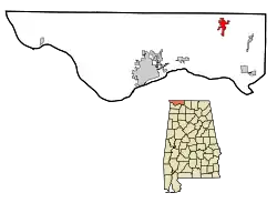 Lage im County und in Alabama | |
| Basisdaten | |
| Staat: | Vereinigte Staaten |
| Bundesstaat: | Alabama |
| County: | Lauderdale County |
| Koordinaten: | 34° 58′ N, 87° 22′ W |
| Zeitzone: | Central (UTC−6/−5) |
| Einwohner: | 727 (Stand: 2020) |
| Fläche: | 8,3 km² (ca. 3 mi²) davon 8,3 km² (ca. 3 mi²) Land |
| Höhe: | 234 m |
| Postleitzahl: | 35648 |
| Vorwahl: | +1 256 |
| FIPS: | 01-42640 |
| GNIS-ID: | 0121530 |
Söhne und Töchter der Stadt
- Joe Louis (1914–1981), Boxer im Schwergewicht
Weblinks
Commons: Lexington (Alabama) – Sammlung von Bildern, Videos und Audiodateien
This article is issued from Wikipedia. The text is licensed under Creative Commons - Attribution - Sharealike. The authors of the article are listed here. Additional terms may apply for the media files, click on images to show image meta data.