Larués
| Gemeinde Bailo: Larués | |||
|---|---|---|---|
 | |||
| Wappen | Karte von Spanien | ||
| ? Hilfe zu Wappen |
| ||
| Basisdaten | |||
| Autonome Gemeinschaft: | |||
| Provinz: | Huesca | ||
| Comarca: | Jacetania | ||
| Koordinaten | 42° 31′ N, 0° 51′ W | ||
| Höhe: | 720 msnm | ||
| Einwohner: | 75 (2015)INE | ||
| Postleitzahl: | 22760 | ||
| Ortskennzahl: | 22044000500 | ||


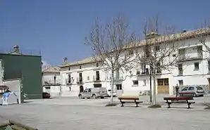
Larués ist ein spanischer Ort im Pyrenäenvorland in der Provinz Huesca der Autonomen Gemeinschaft Aragonien. Larués ist ein Ortsteil der Gemeinde Bailo. Das Dorf auf 720 Meter Höhe hatte 75 Einwohner im Jahr 2015.
Geschichte
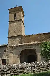
Kirche San Vicente
Der Ort wurde im Jahr 1044 erstmals urkundlich erwähnt.
Sehenswürdigkeiten
- Gotische Pfarrkirche San Vicente
- Ermita San Cristóbal
Literatur
- Huesca. Guía turística del Altoaragón. Editorial Pirineo, Huesca 2003, ISBN 84-87997-68-6, S. 24.
Weblinks
Commons: Larués – Sammlung von Bildern, Videos und Audiodateien
This article is issued from Wikipedia. The text is licensed under Creative Commons - Attribution - Sharealike. The authors of the article are listed here. Additional terms may apply for the media files, click on images to show image meta data.