Kap Dundas
Kap Dundas ist das Ostkap der Insel Laurie Island im Archipel der Südlichen Orkneyinseln nördlich der Antarktischen Halbinsel. Es bildet den Ausläufer der Ferrier-Halbinsel.
| Kap Dundas | ||
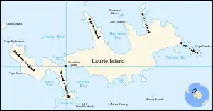 Karte von Laurie Island mit Kap Dundas (rechts) | ||
| Geographische Lage | ||
| ||
| Koordinaten | 60° 43′ S, 44° 25′ W | |
| Lage | Laurie Island, Südliche Orkneyinseln | |
| Küste | Ferrier-Halbinsel | |
| Gewässer | Südlicher Ozean | |
| Gewässer 2 | Fitchie Bay | |

Der britische Seefahrer James Weddell sichtete das Kap am 12. Januar 1823 und benannte es nach der schottischen Familie Dundas, aus der zahlreiche namhafte Politiker hervorgingen.
Weblinks
- Cape Dundas im Geographic Names Information System des United States Geological Survey (englisch)
- Cape Dundas auf geographic.org (englisch)
This article is issued from Wikipedia. The text is licensed under Creative Commons - Attribution - Sharealike. The authors of the article are listed here. Additional terms may apply for the media files, click on images to show image meta data.