Fitchie Bay
Die Fitchie Bay ist eine Bucht an der Südostküste von Laurie Island im Archipel der Südlichen Orkneyinseln. Sie liegt zwischen Kap Dundas und Kap Whitson.
| Fitchie Bay | ||
|---|---|---|
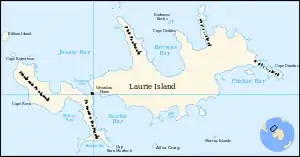 Karte von Laurie Island mit der Fitchie Bay (rechts) | ||
| Gewässer | Weddell-Meer | |
| Landmasse | Laurie Island, Südliche Orkneyinseln | |
| Geographische Lage | 60° 43′ 35″ S, 44° 28′ 28″ W | |
| ||
| Inseln | Baldred Rock, Graptolite Island | |

Kartiert wurde sie bei der Scottish National Antarctic Expedition (1902–1904) unter der Leitung des schottischen Polarforschers William Speirs Bruce. Bruce benannte die Bucht nach John Fitchie (* 1848), Erster Maat auf dem Schiff Scotia bei dieser Forschungsreise.
Weblinks
- Fitchie Bay im Geographic Names Information System des United States Geological Survey (englisch)
- Fitchie Bay auf geographic.org (englisch)
This article is issued from Wikipedia. The text is licensed under Creative Commons - Attribution - Sharealike. The authors of the article are listed here. Additional terms may apply for the media files, click on images to show image meta data.