Kaniksu National Forest
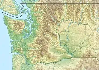
Der Kaniksu National Forest (gesprochen „Kuh-NICK-su“) ist ein National Forest der Vereinigten Staaten im nordöstlichen Washington, im Idaho Panhandle und im nordwestlichen Montana. Er ist eines von dreien zu den Idaho Panhandle National Forests zusammengeführten Staatswaldgebiete; dazu gehören auch der Coeur d’Alene National Forest und der St. Joe National Forest. Der Kaniksu National Forest hat eine Gesamtfläche von 1.627.833 Acres (6.588 km²). Etwa 55,7 % liegen in Idaho, 27,9 % in Montana und 16,4 % in Washington.[1]
Kaniksu National Forest
IUCN-Kategorie VI – Protected Area with Sustainable use of Natural Resources | ||
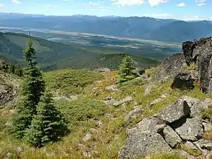 Das Kootenai River Valley im Kaniksu National Forest Das Kootenai River Valley im Kaniksu National Forest | ||
| Lage | Idaho / Montana / Washington, USA | |
| Fläche | 6.587,61 km² | |
| Geographische Lage | 48° 19′ N, 116° 9′ W | |
| ||
| Einrichtungsdatum | 1. Juli 1908 | |
| Verwaltung | United States Forest Service | |
Der Name Kaniksu stammt aus der Sprache der Pend d’Oreille und bedeutet „schwarzes Gewand“. Er wurde benutzt, um jesuitische Missionare zu bezeichnen, die ihren Glauben in Nord-Idaho und Ost-Washington verbreiten wollten.
Geschichte
Der Kaniksu National Forest wurde am 1. Juli 1908 aus einem Teil des Priest River National Forest (Idaho) gegründet. Am 30. September 1933 wurde ein Teil des Pend Oreille National Forest (Idaho/Washington) hinzugefügt, und am 1. Juli 1954 ein Teil des Cabinet National Forest (Idaho/Montana). Der Kaniksu wurde am 1. Juli 1973 administrativ mit dem Coeur d'Alene und dem St. Joe National Forest zusammengeführt.[2]
Der Hauptsitz der Verwaltung befindet sich in Coeur d’Alene (Idaho), der nächstgelegenen Stadt. Es gibt örtliche Bezirksbüros der National Park Ranger in Bonners Ferry, Priest Lake und Sandpoint (alle in Idaho).
Ein Teil der Salmo-Priest Wilderness liegt innerhalb des Kaniksu National Forest; der größte Teil dieses Wildnisgebietes liegt jedoch im westlich benachbarten Colville National Forest. Auch ein Teil (47 %) der Cabinet Mountains Wilderness liegt innerhalb des Kaniksu, der andere Teil (53 %) jedoch im Kootenai National Forest im Norden.[3]
Countys
In absteigender Folge des Flächenanteils liegt der Kaniksu National Forest in folgenden Countys:
- Boundary County (Idaho)
- Sanders County (Montana)
- Bonner County (Idaho)
- Pend Oreille County (Washington)
- Lincoln County (Montana)
- Stevens County (Washington)
- Kootenai County (Idaho)
Siehe auch
- Commons: Idaho Panhandle National Forests – Album mit Bildern, Videos und Audiodateien
Einzelnachweise
- Table 6 - NFS Acreage by State, Congressional District and County. United States Forest Service. 10. Oktober 2007. Abgerufen am 26. Februar 2019.
- Richard C. Davis: National Forests of the United States. The Forest History Society. 29. September 2005. Archiviert vom Original am 12. Februar 2013.
- Wilderness Acreage Breakdown for the Cabinet Mountains Wilderness. In: Wilderness.net. The University of Montana. Abgerufen am 26. Februar 2019.