Kagamil Island
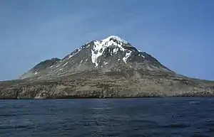
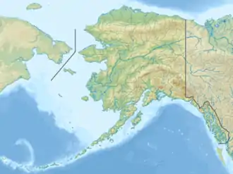
Kagamil Island (aleutisch: Qagaamila) ist eine der Islands of Four Mountains, einer Inselgruppe der Aleuten in Alaska. Sie liegt 6 km nördlich von Chuginadak Island und ist 2 km südlich von Uliaga Island entfernt. Sie ist 10 km lang und 5 km breit. Die Insel ist schwer zu erreichen.
| Kagamil Island | ||
|---|---|---|
Kagamil | ||
| Höhe | 893 m | |
| Lage | Aleuten (Alaska) | |
| Koordinaten | 52° 58′ 26″ N, 169° 43′ 4″ W | |
| ||
| Typ | Schichtvulkan | |
| Letzte Eruption | Dezember 1929 | |
Der Vulkan
Die südliche Hälfte der Insel wird durch den Kagamil-Vulkan bestimmt. Es handelt sich dabei um einen Schichtvulkan. Dieser hat zwei Gipfel, der höhere liegt 893 m über dem Meeresspiegel, der niedrigere ist 690 m hoch. Von der vulkanischen Aktivität zeugen auch heiße Quellen und Fumarolen an der Süd-Ost-Seite der Insel. Der letzte (bekannte) Ausbruch erfolgte im Dezember 1929.
Weblinks
Commons: Kagamil Island – Sammlung von Bildern, Videos und Audiodateien
- Kagamil Island im Global Volcanism Program der Smithsonian Institution (englisch)
- Alaska Vulcano Observatory(engl.)
- National Geographic 1999/2000 (engl.)
- Bild und Kurzbeschreibung (engl.) (Memento vom 23. Dezember 2010 im Internet Archive)
- Canadian Mountain Encyclopedia (engl.)
This article is issued from Wikipedia. The text is licensed under Creative Commons - Attribution - Sharealike. The authors of the article are listed here. Additional terms may apply for the media files, click on images to show image meta data.