Hattonchâtel
| Hattonchâtel | ||
|---|---|---|
.svg.png.webp)
|
| |
| Gemeinde | Vigneulles-lès-Hattonchâtel | |
| Region | Grand Est | |
| Département | Meuse | |
| Arrondissement | Commercy | |
| Koordinaten | 49° 0′ N, 5° 42′ O | |
| Postleitzahl | 55210 | |
| Eingemeindung | 1973 | |
| Status | Commune associée | |
 Hattonchâtel | ||

Hattonchâtel ist ein Ortsteil und eine ehemalige französische Gemeinde im Département Meuse in der Region Grand Est.
Zum 1. März 1973 bildeten die bis dahin eigenständigen Gemeinden Hattonchâtel, Billy-sous-les-Côtes, Creuë, Hattonville, Saint-Benoît-en-Woëvre und Viéville-sous-les-Côtes die neue Gemeinde Vigneulles-lès-Hattonchâtel.
Geographie
Hattonchâtel liegt auf einem Felsvorsprung in der Landschaft Woëvre beim Stausee Lac de Madine.
Geschichte
Der Ort wird erstmals als „Atona“ im Jahr 812 genannt.
Bevölkerungsentwicklung
| Jahr | 1793 | 1831 | 1872 | 1901 | 1921 | 1936 | 1954 | 1962 | 1968 |
| Einwohner | 397 | 505 | 421 | 319 | 122 | 187 | 103 | 82 | 70 |
| Quelle: Cassini und INSEE | |||||||||
Sehenswürdigkeiten
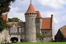
Burg
- Ehemalige Stiftskirche St-Maur, erbaut im 14. Jahrhundert, Monument historique seit 1908; siehe auch Armreliquiar (Hattonchâtel)
- Burg, erbaut ab dem 11. Jahrhundert, Monument historique seit 1986
- Maison de la Voûte, erbaut im 12. Jahrhundert, Monument historique seit 1990
- Maison des Arcades, erbaut vermutlich im 14. Jahrhundert, Monument historique seit 1986
Literatur
- Le Patrimoine des Communes de la Meuse. Flohic Editions, Band 2, Paris 1999, ISBN 2-84234-074-4, S. 1200–1219.
Weblinks
Commons: Hattonchâtel – Sammlung von Bildern, Videos und Audiodateien
This article is issued from Wikipedia. The text is licensed under Creative Commons - Attribution - Sharealike. The authors of the article are listed here. Additional terms may apply for the media files, click on images to show image meta data.