Erma Knoll
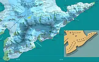
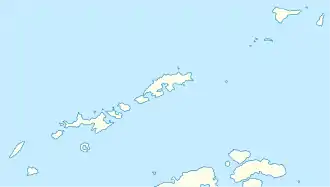
Der Erma Knoll (englisch; bulgarisch Ерменска могила Ermenska mogila) ist ein 412 m hoher Berg auf der Livingston-Insel im Archipel der Südlichen Shetlandinseln. Im Huron-Gletscher ragt er 1,6 km ostsüdöstlich des Kuzman Knoll, 1,3 km nordöstlich des Zograf Peak sowie 390 m nordöstlich des Losen-Nunatak am Nordrand der Tangra Mountains auf.
| Erma Knoll | ||
|---|---|---|

Erma Knoll; links im Hintergrund: Half Moon Island (vorn) und Greenwich Island (hinten) | ||
| Höhe | 412 m | |
| Lage | Livingston-Insel, Südliche Shetlandinseln | |
| Koordinaten | 62° 38′ 31″ S, 60° 8′ 1″ W | |
| ||

Karte der Tangra Mountains mit dem Erma Knoll | ||
Bulgarische Wissenschaftler kartierten ihn zwischen 2004 und 2005. Die bulgarische Kommission für Antarktische Geographische Namen benannte ihn 2005 nach dem Fluss Erma im Westen Bulgariens.
Weblinks
- Erma Knoll im Composite Gazetteer of Antarctica (englisch)
This article is issued from Wikipedia. The text is licensed under Creative Commons - Attribution - Sharealike. The authors of the article are listed here. Additional terms may apply for the media files, click on images to show image meta data.
