Dinalupihan
Dinalupihan ist eine philippinische Stadtgemeinde in der Provinz Bataan. Sie hat 106.371 Einwohner (Zensus 1. August 2015).
| Municipality of Dinalupihan | |||
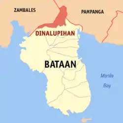
| Lage von Dinalupihan in der Provinz Bataan | |||
|---|---|---|---|
 | |||
| Basisdaten | |||
| Region: | Central Luzon | ||
| Provinz: | Bataan | ||
| Barangays: | 47 | ||
| Distrikt: | 1. Distrikt von Bataan | ||
| PSGC: | 030804000 | ||
| Einkommensklasse: | 1. Einkommensklasse | ||
| Haushalte: | 14.833 Zensus 1. Mai 2000 | ||
| Einwohnerzahl: | 106.371 Zensus 1. August 2015 | ||
| Koordinaten: | 14° 53′ N, 120° 28′ O | ||
| Postleitzahl: | 2110 | ||
| Vorwahl: | +63 47 | ||
| Bürgermeister: | Joel Payumo | ||
| Geographische Lage auf den Philippinen | |||
| |||

Baranggays
Dinalupihan ist politisch unterteilt in 47 Baranggays.
|
|
|
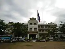
Rathaus von Dinalupihan
Söhne und Töchter
- Manuel Sobreviñas (1924–2020), römisch-katholischer Bischof von Imus
Weblinks
- Informationen über Dinalupihan (englisch)
This article is issued from Wikipedia. The text is licensed under Creative Commons - Attribution - Sharealike. The authors of the article are listed here. Additional terms may apply for the media files, click on images to show image meta data.