Coolaburragundy River
Der Coolaburragundy River ist ein Fluss in der Mitte des australischen Bundesstaates New South Wales.
| Coolaburragundy River | ||
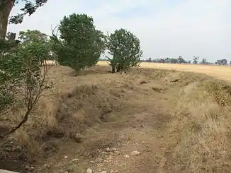
 Coolaburragundy River bei Leadville etwa 1 km vor der Mündung Coolaburragundy River bei Leadville etwa 1 km vor der Mündung | ||
| Daten | ||
| Lage | New South Wales, Australien | |
| Flusssystem | Murray River | |
| Abfluss über | Talbragar River → Macquarie River → Barwon River → Darling River → Murray River → Indischer Ozean | |
| Quelle | bei Coolah Creek, westlich des Coolah-Tops-Nationalparks 31° 44′ 15″ S, 149° 53′ 48″ O | |
| Quellhöhe | 656 m[1] | |
| Mündung | Talbragar River bei Dunedoo 31° 59′ 56″ S, 149° 29′ 3″ O | |
| Mündungshöhe | 391 m[1] | |
| Höhenunterschied | 265 m | |
| Sohlgefälle | 3,8 ‰ | |
| Länge | 68,9 km[1] | |
| Mittelstädte | Coolah | |
| Kleinstädte | Hannahs Bridge, Leadville | |
Verlauf
Er entspringt westlich des Coolah-Tops-Nationalparks am Pandora Pass bei Coolah Creek, fließt nach Südwesten und mündet östlich von Dunedoo in den Talbragar River.
Auf seinem Weg durchfließt er die Stadt Coolah, die Kleinstadt Hannahs Bridge und passiert Leadville nördlich[2].
Einzelnachweise
- Map of Coolaburragundy River, NSW. Bonzle.com
- Steve Parish: Australian Touring Atlas. Steve Parish Publishing Pty. Ltd. Archerfield QLD (2007). ISBN 978174193232-4
This article is issued from Wikipedia. The text is licensed under Creative Commons - Attribution - Sharealike. The authors of the article are listed here. Additional terms may apply for the media files, click on images to show image meta data.