Cambra
Cambra ist eine portugiesische Gemeinde (Freguesia) im Concelho Vouzela. Sie liegt am nordöstlichen Rand der Serra do Caramulo.
| Cambra | ||||||
|---|---|---|---|---|---|---|
| ||||||
| Basisdaten | ||||||
| Region: | Centro | |||||
| Unterregion: | Dão-Lafões | |||||
| Distrikt: | Viseu | |||||
| Concelho: | Vouzela | |||||
| Koordinaten: | 40° 41′ N, 8° 9′ W | |||||
| Einwohner: | 1243 (Stand: 30. Juni 2011)[1] | |||||
| Fläche: | 24,7 km² (Stand: 1. Januar 2010)[2] | |||||
| Bevölkerungsdichte: | 50 Einwohner pro km² | |||||

Im Ort befindet sich ein mittelalterlicher Wehrturm. Die Pfarrkirche des Ortes stammt aus dem 18. Jahrhundert.
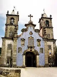
Pfarrkirche São Julião
Einzelnachweise
- www.ine.pt – Indikator Resident population by Place of residence and Sex; Decennial in der Datenbank des Instituto Nacional de Estatística
- Übersicht über Code-Zuordnungen von Freguesias auf epp.eurostat.ec.europa.eu
Weblinks
Commons: Cambra – Sammlung von Bildern, Videos und Audiodateien
- Karte der Freguesia Cambra beim Instituto Geográfico do Exército
Freguesias im Concelho Vouzela
Alcofra | Cambra e Carvalhal de Vermilhas | Campia | Fataunços e Figueiredo das Donas | Fornelo do Monte | Queirã | São Miguel do Mato | Ventosa | Vouzela e Paços de Vilharigues
This article is issued from Wikipedia. The text is licensed under Creative Commons - Attribution - Sharealike. The authors of the article are listed here. Additional terms may apply for the media files, click on images to show image meta data.