Caicos-Inseln
Die Caicos-Inseln (englisch Caicos Islands) sind eine Inselgruppe im Atlantischen Ozean etwa 200 Kilometer nördlich der Insel Hispaniola. Zusammen mit den knapp 40 Kilometer südöstlich liegenden Turks-Inseln bilden sie das Britische Überseegebiet der Turks- und Caicosinseln.
| Caicos-Inseln | ||
|---|---|---|
.jpg.webp) ISS-Astronautenfoto der Caicos-Inseln | ||
| Gewässer | Atlantischer Ozean | |
| Geographische Lage | 21° 39′ N, 71° 54′ W | |
| ||
| Anzahl der Inseln | ca. 30 | |
| Hauptinsel | Providenciales | |
| Gesamte Landfläche | 460,2 km² | |
| Einwohner | 26.519 | |
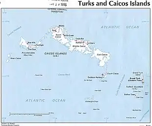 Karte der Turks- und Caicosinseln | ||
Zur Inselgruppe gehören über 30 Inseln, zu den bekannten gehören die Hauptinsel Providenciales sowie West Caicos, North Caicos, Middle Caicos, East Caicos und South Caicos.
Inseln
![]() Karte mit allen Koordinaten: OSM | WikiMap
Karte mit allen Koordinaten: OSM | WikiMap
Diese unvollständige Liste enthält eine Auswahl der Caicos-Inseln (vorsortiert von West nach Ost):
Die Inseln bzw. Cays im Südosten der Caicos Bank, von Bush Cay bis White Cay, sind Teil des Naturschutzgebietes Seal Cays Wildlife Sanctuary.
Literatur
- H. E. Sadler, Marjorie Sadler, Karen Collins: Turks Islands Landfall. A History of the Turks & Caicos Islands. Marjorie E. Sadler, Grand Turk - Turks and Caicos Islands 1997, ISBN 976-8138-62-9.
Einzelnachweise
- 2012 Population and Housing Census – Preliminary Report. (PDF; 1,69 MB) In: caribbeanelections.com. KnowledgeWalk Institute, S. 26, abgerufen am 24. September 2019 (englisch).
Turks-Inseln: Grand Turk | Salt Cay | Cotton Cay | East Cay | Gibbs Cay | Big Sand Cay
Caicos-Inseln: West Caicos | Providenciales | Water Cay | Pine Cay | Stubbs Cay | Fort George Cay | Dellis Cay | Parrot Cay | North Caicos | Middle Caicos | East Caicos | South Caicos | Long Cay | Ambergris Cays (Big Ambergris Cay | Little Ambergris Cay)