Big Sand Cay
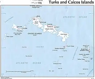
Big Sand Cay ist die südlichste Insel der Turks-Inseln und gehört zum Britischen Überseegebiet der Turks- und Caicosinseln. Sie liegt etwa 11 km südlich der Südspitze von Salt Cay.
| Big Sand Cay | ||
|---|---|---|
| Gewässer | Atlantischer Ozean | |
| Inselgruppe | Turks-Inseln | |
| Geographische Lage | 21° 11′ 33″ N, 71° 14′ 55″ W | |
| ||
| Länge | 2,5 km | |
| Breite | 200 m | |
| Fläche | 58 ha | |
| Einwohner | unbewohnt | |
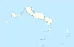
 Karte mit Lage von Big Sand Cay (rechts unten) | ||
Das längliche Big Sand Cay ist flach und kaum bewachsen. Die Insel ist unbewohnt.
Quellen
- Sailing Directions 2004 Caribbean Volume 1 Enroute, Band 1, Seite 35/36
Einige Inseln der Turks- und Caicosinseln
Turks-Inseln: Grand Turk | Salt Cay | Cotton Cay | East Cay | Gibbs Cay | Big Sand Cay
Caicos-Inseln: West Caicos | Providenciales | Water Cay | Pine Cay | Stubbs Cay | Fort George Cay | Dellis Cay | Parrot Cay | North Caicos | Middle Caicos | East Caicos | South Caicos | Long Cay | Ambergris Cays (Big Ambergris Cay | Little Ambergris Cay)
This article is issued from Wikipedia. The text is licensed under Creative Commons - Attribution - Sharealike. The authors of the article are listed here. Additional terms may apply for the media files, click on images to show image meta data.