Arizona State Route 99
Die Arizona State Route 99 (kurz AZ 99) ist eine State Route im US-Bundesstaat Arizona.

| |
|---|---|
| Karte | |
 | |
| Basisdaten | |
| Gesamtlänge: | 44 mi/71 km |
| Eröffnung: | 1969 |
| Anfangspunkt: | am Apache Forest |
| Endpunkt: | in Leupp |
| Countys: | Coconino County Navajo County |
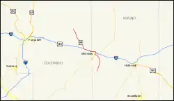
Die State Route beginnt südlich von Winslow, am Apache Forest und endet nahe Leupp im Navajo-Nation-Reservation. Sie verläuft gemeinsam mit der Arizona State Route 87 durch Winslow und nutzt westlich der Stadt für etwa zehn Kilometer die Trasse der Interstate 40 und des U.S. Highways 180. Dieser Abschnitt gehörte zur ehemaligen Route 66.
Weblinks
Commons: Arizona State Route 99 – Sammlung von Bildern, Videos und Audiodateien
This article is issued from Wikipedia. The text is licensed under Creative Commons - Attribution - Sharealike. The authors of the article are listed here. Additional terms may apply for the media files, click on images to show image meta data.