Arizona State Route 87
Die Arizona State Route 87 (kurz AZ 87) ist eine State Route im US-Bundesstaat Arizona. Sie verläuft in Nord-Süd-Richtung von Second Mesa nach Eloy.
| |
|---|---|
| Karte | |
 | |
| Basisdaten | |
| Gesamtlänge: | 288 mi/457 km |
| Anfangspunkt: | |
| Endpunkt: | |
| Countys: | Navajo County Coconino County Gila County Maricopa County Pinal County |
| Wichtige Städte: | Winslow Payson Fountain Hills Mesa Chandler Coolidge |
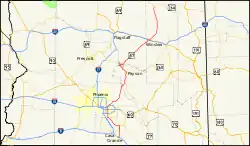
Zwischen Second Mesa und Winslow gibt es auf ungefähr 112 Kilometern Länge keine Ortschaften. Der nächste Ort ist dann das 88 Kilometer entfernte Long Valley. Auf dieser Strecke durchquert sie den Coconino National Forest. Weiter Richtung Strawberry überquert sie die County-Grenze zwischen Coconino County und Gila County. Jetzt durchquert sie den Tonto National Forest bis nach Fountain Hills und verläuft weiter durch das Salt River-Indianerreservat. Mit Mesa folgt die größte Stadt am Highway. 11 Kilometer später kommt die Großstadt Chandler. Danach durchquert er das Gila River-Indianerreservat bis nach Coolidge. In Eloy endet der Highway dann nach 457 Kilometern an der Interstate 10.
Entfernungen zwischen den Städten
- Second Mesa – Winslow 112 km
- Winslow – Long Valley 88 km
- Long-Valley – Strawberry 33 km
- Strawberry – Pine 4 km
- Pine – Payson 25 km
- Payson – Fountain Hills 83 km
- Fountain Hills – Mesa 25 km
- Mesa – Chandler 11
- Chandler – Coolidge 51 km
- Coolidge – Eloy 25 km