Arizona State Route 89A
Die Arizona State Route 89A (kurz AZ 89A) ist eine State Route im US-Bundesstaat Arizona, der in Ost-West-Richtung verläuft.

| |
|---|---|
| Karte | |
 | |
| Basisdaten | |
| Gesamtlänge: | 82 mi/132 km |
| Eröffnung: | 1992 |
| Anfangspunkt: | |
| Endpunkt: | |
| Countys: | Coconino County Yavapai County |
| Wichtige Städte: | Sedona Cottonwood Clarkdale Jerome Prescott Valley |
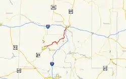
Die State Route beginnt am Interstate 17 nahe Flagstaff und endet nahe Prescott an der Arizona State Route 89. Zwischen Flagstaff und Sedona führt die Straße durch den Oak Creek Canyon über den Mogollon Rim. Sie führt am Tuzigoot National Monument vorbei, bevor sie Clarkdale erreicht. Bis 1992 gehörte die Straße zum U.S. Highway 89A, der aber in diesem Abschnitt aufgelöst wurde.
Weblinks
Commons: Arizona State Route 89A – Sammlung von Bildern, Videos und Audiodateien
- Arizona Roads (englisch)
- AARoads (englisch)
This article is issued from Wikipedia. The text is licensed under Creative Commons - Attribution - Sharealike. The authors of the article are listed here. Additional terms may apply for the media files, click on images to show image meta data.