Aiguille de la Tsa
Der Aiguille de la Tsa ist ein 3668 m ü. M. hoher Berg im Kanton Wallis, eine ins Auge stechende Nadel im Kamm zwischen Arolla und Ferpècle.
| Aiguille de la Tsa | ||
|---|---|---|
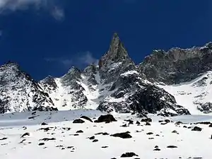 | ||
| Höhe | 3668 m ü. M. | |
| Lage | Kanton Wallis, Schweiz | |
| Gebirge | Walliser Alpen | |
| Dominanz | 1,74 km → Pointe des Genevois | |
| Schartenhöhe | 251 m ↓ am Grat nach Norden | |
| Koordinaten | 606472 / 96653 | |
| ||
| Erstbesteigung | 1868 | |
| Normalweg | über Ostseite (III (Stelle), II) | |
Weblinks
Commons: Aiguille de la Tsa – Sammlung von Bildern, Videos und Audiodateien
This article is issued from Wikipedia. The text is licensed under Creative Commons - Attribution - Sharealike. The authors of the article are listed here. Additional terms may apply for the media files, click on images to show image meta data.