Vallis Bouvard
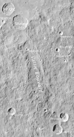
Das Vallis Bouvard ist ein Mondtal am äußersten westlichen Rand der Mondvorderseite. Es erstreckt sich über eine Strecke von fast 300 Kilometern von einem Punkt nordöstlich des Kraters Baade, nahe dem Krater Bouvard D, in nordöstlicher Richtung bis in die Nähe des Kraters Shaler. Es weist damit ebenso wie die benachbarten Strukturen des Vallis Baade und Vallis Inghirami in Richtung auf das große Einschlagbecken des Mare Orientale. An der weitesten Stelle ist es ungefähr 50 km breit.
| Vallis Bouvard | ||
|---|---|---|
 | ||
| Vallis Bouvard (LROC-WAC) | ||
| ||
| Position | 38,44° S, 83,56° W | |
| Durchmesser | 288 km | |
| Benannt nach | Alexis Bouvard (1767–1843). | |
| Siehe auch Gazetteer of Planetary Nomenclature | ||
Das Vallis Bouvard ist das einzige Mondtal, das namengebend für eine Gruppe von Nebenkratern ist:
| Buchstabe | Position | Durchmesser | Link |
|---|---|---|---|
| B | 41,71° S, 79,82° W | 25 km | |
| C | 37,09° S, 77,48° W | 15 km | |
| D | 42,77° S, 80,66° W | 27 km | |
| E | 41,9° S, 77,53° W | 13 km | |
| F | 42,46° S, 76,55° W | 12 km | |
| G | 42,07° S, 74,74° W | 20 km | |
| M | 40,61° S, 77,52° W | 74 km | |
| N | 38,57° S, 76,52° W | 66 km | |
| P | 38,92° S, 75,16° W | 14 km | |
| R | 35,56° S, 84,38° W | 8 km | |
| S | 35,62° S, 80,63° W | 12 km |
Die Struktur wurde 1970 von der IAU nach dem französischen Astronomen und Mathematiker Alexis Bouvard offiziell benannt.
Weblinks
- Vallis Bouvard im Gazetteer of Planetary Nomenclature der IAU (WGPSN) / USGS
- Vallis Bouvard auf The-Moon Wiki
This article is issued from Wikipedia. The text is licensed under Creative Commons - Attribution - Sharealike. The authors of the article are listed here. Additional terms may apply for the media files, click on images to show image meta data.
