Valdez-Cordova Census Area
Der Valdez-Cordova Census Area war bis 2019 eine Census Area im US-Bundesstaat Alaska. Sie erstreckte sich vom Prinz-William-Sund entlang der Küste des Golfs von Alaska bis zur Grenze zum kanadischen Territorium Yukon und beinhaltete das Delta des Copper River.
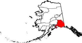
Im Jahr 2010 betrug die Bevölkerungszahl 9.636. Valdez-Cordova gehörte zum Unorganized Borough und hatte somit keinen Verwaltungssitz. Die Census Area hatte eine Fläche von 104.115 km², wovon 88.886 km² auf Land und 15.229 km² auf Wasser entfielen. Die größte Stadt der Region war Valdez.
Am 2. Januar 2019 wurde die Census Area in die Chugach Census Area und die Copper River Census Area aufgespalten.
Weblinks
- QuickFacts auf census.gov (englisch)
Einzelnachweise
- Listing of National Historic Landmarks by State: Alaska. National Park Service, abgerufen am 1. Mai 2020.
| Boroughs |
Aleutians East | Anchorage | Bristol Bay | Denali | Fairbanks North Star | Haines | Juneau | Kenai Peninsula | Ketchikan Gateway | Kodiak Island | Lake and Peninsula | Matanuska-Susitna | North Slope | Northwest Arctic | Petersburg Borough | Skagway | Sitka | Wrangell | Yakutat | Unorganized Borough |
|
| Census Areas |
Aleutians West | Bethel | Chugach | Copper River | Dillingham | Hoonah-Angoon | Kusilvak | Nome | Prince of Wales-Hyder | Southeast Fairbanks | Yukon-Koyukuk |