Utamboni
Der Utamboni ist ein Fluss im südwestlichen Äquatorialguinea, entlang der Grenze zu Gabun.
| Utamboni Mitemele | ||
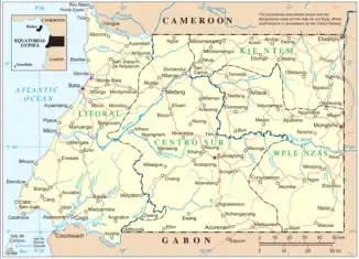 Der Fluss befindet sich ganz an der südlichsten Spitze an der Grenze zu Gabun Der Fluss befindet sich ganz an der südlichsten Spitze an der Grenze zu Gabun | ||
| Daten | ||
| Lage | Grenze | |
| Flusssystem | Muni | |
| Abfluss über | Muni → Bucht von Bonny | |
| Quelle | als Mitemele in der äquatorialguineischen Provinz Centro Sur | |
| Mündung | an der Grenze zwischen Äquatorialguinea (Provinz Litoral) und Gabun (Provinz Estuaire) in den Muni 1° 4′ 8″ N, 9° 47′ 44″ O | |
| Mündungshöhe | 8 m
| |
Verlauf
Der Fluss entspringt als Mitemele in Äquatorialguinea, in der Provinz Centro Sur und fließt in südwestliche Richtung. Er bildet zunächst die Grenze zwischen der Provinz Centro Sur und der Provinz Litoral, später zwischen Äquatorialguinea und Gabun. Der Fluss mündet als Utamboni aus Osten kommend in den Muni.[1][2]
Einzelnachweise
- Jane S. Hughes, G. M. Bernacsek, IUCN--The World Conservation Union, United Nations Environment Programme, World Conservation Monitoring Centre: A directory of African wetlands. IUCN, Gland, Switzerland 1992, ISBN 2-88032-949-3, S. 501 (google.de [abgerufen am 1. März 2021]).
- I. K. Sundiata: Equatorial Guinea : colonialism, state terror, and the search for stability. Westview Press, Boulder 1990, ISBN 0-8133-0429-6, S. 20 und 24 (archive.org [abgerufen am 1. März 2021]).
This article is issued from Wikipedia. The text is licensed under Creative Commons - Attribution - Sharealike. The authors of the article are listed here. Additional terms may apply for the media files, click on images to show image meta data.