Teafatule
Teafatule ist eine kleine Riffinsel im Riffsaum des Atolls Nukulaelae im Inselstaat Tuvalu.[1][2]
| Teafatule | ||
|---|---|---|
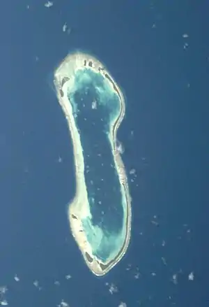 Satellitenbild des Nukulaelae-Atolls. | ||
| Gewässer | Pazifischer Ozean | |
| Inselgruppe | Nukulaelae | |
| Geographische Lage | 9° 25′ S, 179° 51′ O | |
| ||
Geographie
Teafatule bildet zusammen mit Fenulaiago, Aula, Temotutafa, Temotuloto und Teafatule den südlichen Riffsaum des Atolls.[3] Die Insel ist auch die südwestliche Landspitze des Atolls. Von dort zieht sich das Unbroken Western Reef (Te Akua Fakalava) nach Norden.
Einzelnachweise
- Map of Nukulaelae Atoll. Tuvaluislands.com.
- British Admiralty Nautical Chart 766 Ellice Islands. 21 March 1872, United Kingdom Hydrographic Office (UKHO) 1893.
- geonames.org.
This article is issued from Wikipedia. The text is licensed under Creative Commons - Attribution - Sharealike. The authors of the article are listed here. Additional terms may apply for the media files, click on images to show image meta data.