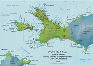
Rugged Island (Südliche Shetlandinseln)
Rugged Island (in Argentinien Isla Rugosa; vormals Lloyds Island und Ragged Island) ist eine unbewohnte Insel im Archipel der Südlichen Shetlandinseln in der Antarktis. Sie wurde bereits Weihnachten 1819 vom britischen Robbenjäger Joseph Herring entdeckt, der im Nordosten der Insel an der Hersilia Cove an Land ging und die Insel für König Georg III. in Besitz nahm.
| Rugged Island | ||
|---|---|---|
 | ||
| Gewässer | Drakestraße | |
| Inselgruppe | Südliche Shetlandinseln | |
| Geographische Lage | 62° 37′ 59″ S, 61° 15′ 0″ W | |
| ||
| Länge | 6 km | |
| Breite | 2 km | |
| Fläche | 10,4 km² | |
| Höchste Erhebung | San Stefano Peak 256 m | |
| Einwohner | unbewohnt | |

Geographie
Rugged Island liegt in der Drakestraße. Zwischen ihr und der etwa 3 km östlich befindlichen Livingston-Insel liegen die Bucht New Plymouth und die Osogovo Bay. Von Snow Island sind beide Inseln durch die Morton Strait getrennt. Rugged Island ist rund 6 km lang, bis 2 km breit und 10,4 km² groß.[1] Die Insel ist nicht vergletschert.
Weblinks
- Rugged Island im Australian Antarctic Data Center (englisch)
Einzelnachweise
- L. L. Ivanov: Antarctica: Livingston Island and Greenwich, Robert, Snow and Smith Islands. Topografische Karte im Maßstab 1:120.000. Manfred-Wörner-Stiftung, Troyan, 2009. ISBN 978-954-92032-6-4
This article is issued from Wikipedia. The text is licensed under Creative Commons - Attribution - Sharealike. The authors of the article are listed here. Additional terms may apply for the media files, click on images to show image meta data.