Rotuma (Kiribati)
Rotuma ist ein Ort im Osten des Nonouti-Atolls in den Gilbertinseln des Inselstaats Kiribati im Pazifischen Ozean.[1] 2017 hatte der Ort ca. 397 Einwohner.
| Rotuma Rotuma | |||
|---|---|---|---|
| |||
| Koordinaten | 0° 38′ S, 174° 25′ O | ||
| Basisdaten | |||
| Staat | Kiribati | ||
| Gilbertinseln | |||
| Einwohner | 397 (2017) | ||
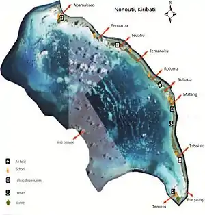 Satellitenkarte von Nonouti Satellitenkarte von Nonouti | |||

Geographie
Rotuma liegt im Osten von Nonouti in der Nähe der Mitte der Hauptinsel zwischen Temanoku im Norden und dem Flugplatz Nonouti im Süden, beziehungsweise Autukia.[2] Im Ort gibt es ein traditionelles Versammlungshaus: Rotuma Maneaba, sowie die Roman Catholic Church Bwatimwa. Auch der Inselteil ist „Rotuma“ benannt. Der Hauptort Taboiaki liegt etwa 12,7 km weiter südlich.
Klima
Das Klima ist tropisch heiß, wird jedoch von ständig wehenden Winden gemäßigt. Ebenso wie die anderen Orte des Nonouti-Atolls wird Rotuma gelegentlich von Zyklonen heimgesucht.
Einzelnachweise
- Office of Te Beretitenti - Republic of Kiribati Island Report Series. 11. Nonouti 2012
- Rotuma bei GeoNames, geonames.org. Abgerufen am 12. September 2021.
This article is issued from Wikipedia. The text is licensed under Creative Commons - Attribution - Sharealike. The authors of the article are listed here. Additional terms may apply for the media files, click on images to show image meta data.