Rothera Point
Der Rothera Point ist eine Landspitze im Südosten der Adelaide-Insel westlich der Antarktischen Halbinsel. Sie liegt auf der Ostseite der Einfahrt zur Ryder Bay.
| Rothera Point | ||
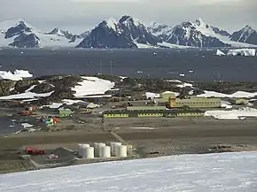 Die Rothera-Station auf dem Rothera Point | ||
| Geographische Lage | ||
| ||
| Koordinaten | 67° 34′ S, 68° 8′ W | |
| Lage | Adelaide-Insel (Westantarktika) | |
| Gewässer | Cole Channel | |
| Gewässer 2 | Ryder Bay | |

Teilnehmer der Fünften Französischen Antarktisexpedition (1908–1910) unter der Leitung des Polarforschers Jean-Baptiste Charcot kartierten sie. Das UK Antarctic Place-Names Committee benannte sie 1960 nach John Michael Rothera (* 1935), Geodät des Falkland Islands Dependencies Survey auf der Station von Horseshoe Island im Jahr 1957 und der Station auf der Detaille-Insel im Jahr darauf. Die Landspitze ist seit 1975 Standort der britischen Rothera-Station.
Weblinks
- Rothera Point im Geographic Names Information System des United States Geological Survey (englisch)
- Rothera Point auf geographic.org (englisch)
This article is issued from Wikipedia. The text is licensed under Creative Commons - Attribution - Sharealike. The authors of the article are listed here. Additional terms may apply for the media files, click on images to show image meta data.