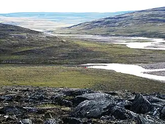
Rivière Vachon
Der Rivière Vachon ist ein linker Nebenfluss des Rivière Arnaud im Norden der Ungava-Halbinsel in der kanadischen Provinz Québec.
| Rivière Vachon | ||
 | ||
| Daten | ||
| Lage | Québec (Kanada) | |
| Flusssystem | Rivière Arnaud | |
| Abfluss über | Rivière Arnaud → Ungava Bay | |
| Ursprung | Lac Manarsulik 61° 19′ 17″ N, 73° 39′ 46″ W | |
| Quellhöhe | 549 m | |
| Mündung | Rivière Arnaud 60° 4′ 45″ N, 71° 8′ 59″ W | |
| Mündungshöhe | 84 m | |
| Höhenunterschied | 465 m | |
| Sohlgefälle | ca. 1,9 ‰ | |
| Länge | ca. 250 km | |
| Einzugsgebiet | 10.400 km²[1] | |
| Linke Nebenflüsse | Rivière Kimber, Rivière Trant | |
| Rechte Nebenflüsse | Rivière Leridon, Rivière Lestage | |
Der Rivière Vachon entspringt dem im Parc national des Pingualuit gelegenen See Lac Manarsulik. Der Fluss fließt in überwiegend südöstlicher Richtung durch den Nordostteil der Ungava-Halbinsel und mündet schließlich in den Unterlauf des Rivière Arnaud. Der Fluss hat eine Länge von etwa 250 km. Das Einzugsgebiet des Rivière Vachon umfasst 10.400 km². Wichtige Nebenflüsse sind Rivière Kimber und Rivière Trant von links sowie Rivière Leridon und Rivière Lestage von rechts.
Einzelnachweise
- Water Survey of Canada: Station 03HA015 (Memento des Originals vom 24. Dezember 2010) Info: Der Archivlink wurde automatisch eingesetzt und noch nicht geprüft. Bitte prüfe Original- und Archivlink gemäß Anleitung und entferne dann diesen Hinweis.
This article is issued from Wikipedia. The text is licensed under Creative Commons - Attribution - Sharealike. The authors of the article are listed here. Additional terms may apply for the media files, click on images to show image meta data.