Rivière Nastapoka
Der Fluss Rivière Nastapoka (englisch Nastapoka River) ist ein größerer Strom in der Verwaltungsregion Nord-du-Québec in der kanadischen Provinz Québec, welcher den Parc national Tursujuq durchfließt.
| Rivière Nastapoka | ||
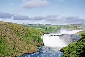 Wasserfall am Rivière Nastapoka Wasserfall am Rivière Nastapoka | ||
| Daten | ||
| Lage | Nunavik, Nord-du-Québec in Québec (Kanada) | |
| Flusssystem | Rivière Nastapoka | |
| Ursprung | Lacs des Loups Marins 56° 30′ 31″ N, 73° 44′ 58″ W | |
| Quellhöhe | 262 m | |
| Mündung | Hudson Bay 56° 54′ 38″ N, 76° 32′ 46″ W | |
| Mündungshöhe | 0 m | |
| Höhenunterschied | 262 m | |
| Sohlgefälle | 0,73 ‰ | |
| Länge | 360 km[1] | |
| Einzugsgebiet | 13.400 km²[1] | |
| Abfluss am Pegel Lacs des Loups Marins[2] AEo: 8390 km² |
MQ 1974/1997 Mq 1974/1997 |
192 m³/s 22,9 l/(s km²) |
| Abfluss am Pegel nahe der Mündung[3] AEo: 12.500 km² |
MQ 1974/1993 Mq 1974/1993 |
239 m³/s 19,1 l/(s km²) |
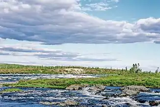 Stromschnellen am Rivière Nastapoka Stromschnellen am Rivière Nastapoka | ||
Er hat eine Länge von 360 km und ein Einzugsgebiet von 13.400 km².[1] Der Fluss hat seinen Ursprung in den Lacs des Loups Marins. Von dort fließt er in westlicher Richtung durch die westliche Labrador-Halbinsel und mündet in den Chenal Nastapoka und in die Hudson Bay. Gegenüber seiner Mündung liegt der Küstenarchipel Îles Nastapoka. Die Flussmündung liegt etwa 40 km nördlich der Inuit-Siedlung Umiujaq und der Inlandsbucht Lac Guillaume-Delisle.
Weblinks
Commons: Rivière Nastapoka – Sammlung von Bildern, Videos und Audiodateien
Einzelnachweise
- Natural Resources Canada - The Atlas of Canada - Rivers
- Rivière Nastapoka am Pegel Lacs des Loups Marins – hydrographische Daten bei R-ArcticNET
- Rivière Nastapoka am Pegel nahe der Mündung – hydrographische Daten bei R-ArcticNET
This article is issued from Wikipedia. The text is licensed under Creative Commons - Attribution - Sharealike. The authors of the article are listed here. Additional terms may apply for the media files, click on images to show image meta data.