Rivière Croche
Der Rivière Croche ist ein linker Nebenfluss des Rivière Saint-Maurice in der Verwaltungsregion Mauricie der kanadischen Provinz Québec.
| Rivière Croche | ||
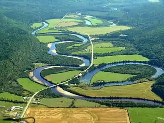 Rivière Croche im Unterlauf oberhalb der Ortschaft La Croche Rivière Croche im Unterlauf oberhalb der Ortschaft La Croche | ||
| Daten | ||
| Lage | Mauricie in Québec (Kanada) | |
| Flusssystem | Sankt-Lorenz-Strom | |
| Abfluss über | Rivière Saint-Maurice → Sankt-Lorenz-Strom → Atlantischer Ozean | |
| Ursprung | Lac du Caribou 48° 24′ 23″ N, 72° 43′ 50″ W | |
| Quellhöhe | 408 m | |
| Mündung | Rivière Saint-Maurice 47° 29′ 40″ N, 72° 46′ 27″ W | |
| Mündungshöhe | 131 m | |
| Höhenunterschied | 277 m | |
| Sohlgefälle | ca. 1,8 ‰ | |
| Länge | ca. 150 km[1] | |
| Einzugsgebiet | 1968 km² | |
| Abfluss am Pegel La Croche[2] AEo: 1850 km² |
MQ 1938/1965 Mq 1938/1965 |
36 m³/s 19,5 l/(s km²) |
| Gemeinden | La Croche | |
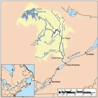 Lage des Rivière Croche im Einzugsgebiet des Rivière Saint-Maurice Lage des Rivière Croche im Einzugsgebiet des Rivière Saint-Maurice | ||
Der Rivière Croche hat seinen Ursprung im See Lac du Caribou auf etwa 400 m Höhe. Er durchfließt die Laurentinischen Berge in südlicher Richtung. Im Unterlauf entwickelt der Fluss zahlreiche enge Flussschlingen. Der Rivière Croche mündet 5 km nördlich von La Tuque in den Saint-Maurice. Der Fluss hat eine Länge von etwa 150 km.
Weblinks
Commons: Rivière Croche – Sammlung von Bildern, Videos und Audiodateien
Einzelnachweise
This article is issued from Wikipedia. The text is licensed under Creative Commons - Attribution - Sharealike. The authors of the article are listed here. Additional terms may apply for the media files, click on images to show image meta data.