Rivière Bonaventure
Der Rivière Bonaventure ist ein Fluss in der Verwaltungsregion Gaspésie–Îles-de-la-Madeleine der kanadischen Provinz Québec.
| Rivière Bonaventure | ||
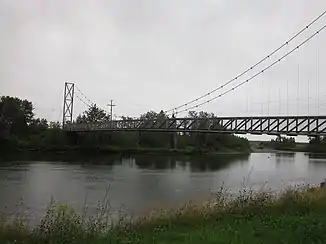
 Hängebrücke über den Rivière Bonaventure im Réserve aquatique de l’Estuaire-de-la-Rivière-Bonaventure bei Bonaventure Hängebrücke über den Rivière Bonaventure im Réserve aquatique de l’Estuaire-de-la-Rivière-Bonaventure bei Bonaventure | ||
| Daten | ||
| Lage | Gaspésie–Îles-de-la-Madeleine in Québec (Kanada) | |
| Flusssystem | Rivière Bonaventure | |
| Quelle | in den Monts Chic-Chocs | |
| Quellhöhe | ca. 700 m | |
| Mündung | Chaleur-Bucht (Sankt-Lorenz-Golf) | |
| Mündungshöhe | 0 m | |
| Höhenunterschied | ca. 700 m | |
| Sohlgefälle | ca. 4,9 ‰ | |
| Länge | 142 km[1] | |
| Einzugsgebiet | 2401 km²[1] | |
| Abfluss am Pegel oberhalb des Ruisseau Creux[2] AEo: 1910 km² |
MQ 1982/2001 Mq 1982/2001 |
38 m³/s 19,9 l/(s km²) |
| Abfluss[1] | MQ |
50 m³/s |
| Linke Nebenflüsse | Rivière Reboul, Rivière Garin, Rivière Hall | |
| Rechte Nebenflüsse | Rivière Bonaventure Ouest | |
| Kleinstädte | Bonaventure | |
Der Rivière Bonaventure entspringt in den Monts Chic-Chocs im Zentrum der Gaspésie-Halbinsel. Er fließt in südlicher Richtung durch die regionale Grafschaftsgemeinde Bonaventure zur Chaleur-Bucht, in die er bei Bonaventure mündet. Der Fluss hat eine Länge von 142 km. Er entwässert ein Areal von 2401 km². Der mittlere Abfluss beträgt 50 m³/s.

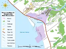
Mündungsgebiet des Rivière Bonaventure
Weblinks
Commons: Rivière Bonaventure – Sammlung von Bildern, Videos und Audiodateien
Einzelnachweise
- Bureau d'audiences publiques sur l'environnement (PDF; 103 kB)
- Water Survey of Canda: Station 01BG009 (Memento des Originals vom 24. Dezember 2010) Info: Der Archivlink wurde automatisch eingesetzt und noch nicht geprüft. Bitte prüfe Original- und Archivlink gemäß Anleitung und entferne dann diesen Hinweis.
This article is issued from Wikipedia. The text is licensed under Creative Commons - Attribution - Sharealike. The authors of the article are listed here. Additional terms may apply for the media files, click on images to show image meta data.