Ray Promontory
Die Ray Promontory ist eine erhöhte Halbinsel der Livingston-Insel im Archipel der Südlichen Shetlandinseln. Sie bildet den nordwestlichen Ausläufer der Byers-Halbinsel, endet im Nordwesten mit dem Start Point und im Nordosten am Essex Point. Nahe ihrer Basis ragt der Penca Hill auf.
| Ray Promontory | ||
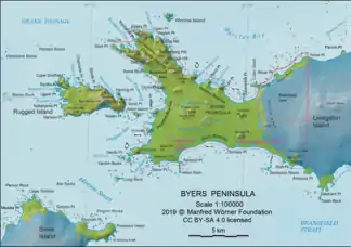 Karte der Byers-Halbinsel (Livingston-Insel) mit der Ray Promontory | ||
| Geographische Lage | ||
| ||
| Koordinaten | 62° 36′ 0″ S, 61° 7′ 40″ W | |
| Lage | Livingston-Insel (Südliche Shetlandinseln) | |
| Gewässer 1 | Drakestraße | |
| Gewässer 2 | New Plymouth | |
| Gewässer 3 | Svishtov Cove und Richards Cove | |
| Gewässer 4 | Barclay Bay | |

Das UK Antarctic Place-Names Committee benannte sie 1977 nach Nathaniel Ray (1771–1830), Kapitän des Schoners Harmony aus Nantucket zur Robbenjagd in der Harmony Cove von Nelson Island zwischen 1820 und 1821.
Weblinks
- Ray Promontory im Geographic Names Information System des United States Geological Survey (englisch)
- Ray Promontory auf geographic.org (englisch)
This article is issued from Wikipedia. The text is licensed under Creative Commons - Attribution - Sharealike. The authors of the article are listed here. Additional terms may apply for the media files, click on images to show image meta data.