Barclay Bay
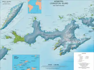
Die Barclay Bay ist eine Bucht an der Nordküste der Livingston-Insel im Archipel der Südlichen Shetlandinseln. Sie liegt zwischen Kap Shirreff an der Nordspitze der Johannes-Paul-II.-Halbinsel und dem Essex Point am nordwestlichen Ende der Byers-Halbinsel.
| Barclay Bay | ||
|---|---|---|
 Karte der Livingston-Insel mit der Barclay Bay (Mitte links) Karte der Livingston-Insel mit der Barclay Bay (Mitte links) | ||
| Gewässer | Drakestraße | |
| Landmasse | Livingston-Insel, Südliche Shetlandinseln | |
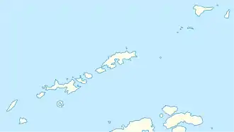
| Geographische Lage | 62° 33′ 58″ S, 60° 57′ 58″ W | |
| ||
| Inseln | Cutler Stack, Frederick Rocks, Orsini Rock, Ramsden Rock, Sisson Rock, Window Island | |
| Zuflüsse | Bedek Stream, Eridanus Stream, Etar-Schneefeld | |
Der Name der Bucht ist erstmals auf Kartenmaterial des britischen Seefahrers James Weddell aus dem Jahr 1825 zu finden. Der Benennungshintergrund bzw. der Namensgeber ist unbekannt.
Weblinks
- Barclay Bay im Geographic Names Information System des United States Geological Survey (englisch)
- Barclay Bay auf geographic.org (englisch)
This article is issued from Wikipedia. The text is licensed under Creative Commons - Attribution - Sharealike. The authors of the article are listed here. Additional terms may apply for the media files, click on images to show image meta data.
