Piz da Cävi
Der Piz da Cävi ist ein Berg im Schweizer Kanton Graubünden.
| Piz da Cävi | ||
|---|---|---|
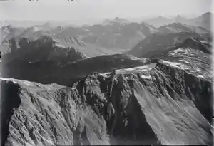
historisches Luftbild von 1923 | ||
| Höhe | 2843 m ü. M. | |
| Lage | Kanton Graubünden, Schweiz | |
| Koordinaten | 760285 / 137064 | |
| ||
Der Gipfel liegt auf einer Höhe von 2843 m ü. M. und gehört zum Gemeindegebiet von Bregaglia.
Literatur
- Landeskarte der Schweiz 1:25'000, Blatt 1276 Val Bregaglia. Bundesamt für Landestopografie, Wabern 2017, ISBN 978-3-302-01276-6.
- Charles Knapp, Maurice Borel, Victor Attinger, Heinrich Brunner, Société neuchâteloise de géographie (Herausgeber): Geographisches Lexikon der Schweiz. Band 1: Aa – Emmengruppe. Verlag Gebrüder Attinger, Neuenburg 1902, S. 430, Stichwort Cavio (Cima di) (Scan der Lexikon-Seite).
This article is issued from Wikipedia. The text is licensed under Creative Commons - Attribution - Sharealike. The authors of the article are listed here. Additional terms may apply for the media files, click on images to show image meta data.