Piñera (Uruguay)
| Piñera | ||
|---|---|---|
|
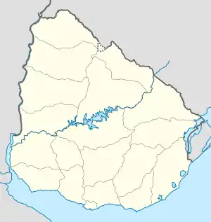
Piñera auf der Karte von Uruguay | ||
| Basisdaten | ||
| Staat | Uruguay | |
| Departamento | Paysandú | |
| Einwohner | 118 (2004) | |
| Detaildaten | ||
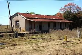
 Bahnstation in Piñera | ||
Piñera ist eine Ortschaft in Uruguay.
Geographie
Sie befindet sich auf dem Gebiet des Departamento Paysandú in dessen Sektor 5. Piñera liegt etwa 20 Kilometer ostnordöstlich von Guichón sowie nordwestlich von Merinos. Im Norden grenzt Beisso an. Etwa zwei Kilometer südlich der Ortschaft verläuft die Grenze zum Nachbardepartamento Río Negro.
Geschichte
Am 21. August 1936 wurde Piñera der Status "Pueblo" durch das Gesetz Nr.9.588 zuerkannt.
Einwohner
Für Piñera wurden bei der Volkszählung im Jahr 2004 118 Einwohner registriert[1].
| Jahr | Einwohner |
|---|---|
| 1963 | 313 |
| 1975 | 261 |
| 1985 | 189 |
| 1996 | 193 |
| 2004 | 118 |
Quelle: Instituto Nacional de Estadística de Uruguay[2]
.jpg.webp) Escuela Nº 17 "José María Firpo"
Escuela Nº 17 "José María Firpo" Almacén de Ramos Generales
 Capilla María Auxiliadora
Weblinks
- Stadtplan von Piñera (PDF; 85 kB)
Einzelnachweise
This article is issued from Wikipedia. The text is licensed under Creative Commons - Attribution - Sharealike. The authors of the article are listed here. Additional terms may apply for the media files, click on images to show image meta data.
