Ongley Island
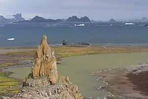
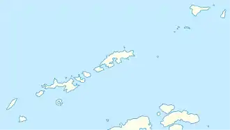
Ongley Island ist eine kleine Insel im Archipel der Südlichen Shetlandinseln. Sie liegt 4 km westlich von Dee Island nahe der Nordküste von Greenwich Island.
| Ongley Island | ||
|---|---|---|
 Blick von Barrientos Island auf Onlgey Island und der dahinter liegenden Greenwich Island | ||
| Gewässer | Drakestraße | |
| Inselgruppe | Südliche Shetlandinseln | |
| Geographische Lage | 62° 25′ 48″ S, 59° 53′ 21″ W | |
| ||
| Länge | 1,35 km | |
| Breite | 470 m | |
| Fläche | 44 ha | |
| Einwohner | unbewohnt | |
Die Insel wurde 1935 von Wissenschaftlern der britischen Discovery Investigations kartiert. Benannt ist sie nach Leonard Thomas Ongley (1899–1944), Kartograf des United Kingdom Hydrographic Office.[1]
Weblinks
- Ongley Island im Geographic Names Information System des United States Geological Survey (englisch)
- Ongley Island auf geographic.org (englisch)
Einzelnachweise
- Ongley Island in der Datenbank des Australian Antarctic Data Center (englisch, abgerufen am 21. März 2016).
This article is issued from Wikipedia. The text is licensed under Creative Commons - Attribution - Sharealike. The authors of the article are listed here. Additional terms may apply for the media files, click on images to show image meta data.
