North Fork Eel River
Der North Fork Eel River ist ein rechter Nebenfluss des Eel River im Nordwesten des US-Bundesstaates Kalifornien. Der 53 km lange Fluss entwässert ein Areal von 729 km².
| North Fork Eel River | ||
 Flusslauf im Einzugsgebiet des Eel River Flusslauf im Einzugsgebiet des Eel River | ||
| Daten | ||
| Gewässerkennzahl | US: 255113 | |
| Lage | Kalifornien (USA) | |
| Flusssystem | Eel River | |
| Abfluss über | Eel River → Pazifischer Ozean | |
| Zusammenfluss von | West Fork und East Fork North Fork Eel River im Trinity County 40° 12′ 49″ N, 123° 23′ 14″ W | |
| Quellhöhe | 645 m[1] | |
| Mündung | 9,6 km nördlich von Spyrock in den Eel River 39° 57′ 24″ N, 123° 26′ 14″ W | |
| Mündungshöhe | 175 m[2] | |
| Höhenunterschied | 470 m | |
| Sohlgefälle | 8,9 ‰ | |
| Länge | 53 km[2] | |
| Einzugsgebiet | 729 km²[3] | |
| Abfluss am Pegel Mina[4] AEo: 642 km² |
MQ 1954/2005 Mq 1954/2005 |
18 m³/s 28 l/(s km²) |
| Einwohner im Einzugsgebiet | 200 | |
| National Wild and Scenic River | ||
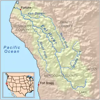
Der North Fork Eel River entsteht am Zusammenfluss von West Fork North Fork Eel River und East Fork North Fork Eel River 6,4 km nordöstlich von Zenia im Trinity County.[2] Er strömt in überwiegend südlicher Richtung durch das Kalifornische Küstengebirge. Der North Fork Eel River mündet schließlich 9,6 km nördlich von Spyrock im Mendocino County in den Eel River.
Das Einzugsgebiet des North Eel River ist sehr gering besiedelt. Das Gelände umfasst bewaldete Gebiete, Eichenwälder und Eichensavannen sowie offenes Weideland.[3] Etwa 41 % des Einzugsgebietes liegen innerhalb des Six Rivers National Forest.[3]
Am 19. Januar 1981 wurden insgesamt 640 km im Flusssystem des Eel River als National Wild and Scenic River ausgezeichnet.[5] Der Flussabschnitt des North Fork Eel River von seiner Mündung bis zur Old Gilman Ranch wurde dabei unter Schutz gestellt.[5]
Auf den unteren 8 Kilometern unterhalb Split Rock findet man den Königslachs (chinook) im North Fork Eel River.[3] Steelhead-Forellen sind im Flusslauf häufig anzutreffen.[3]
Einzelnachweise
- West Fork North Fork Eel River im Geographic Names Information System des United States Geological Survey
- North Fork Eel River im Geographic Names Information System des United States Geological Survey
- North Fork Eel River, Total Maximum Daily Loads for Sediment and Temperature (PDF, 625 KB) US EPA. Abgerufen am 12. August 2017.
- USGS 11474500 NF EEL R NR MINA CA
- National Wild and Scenic Rivers System: Eel River, California