Nakolo
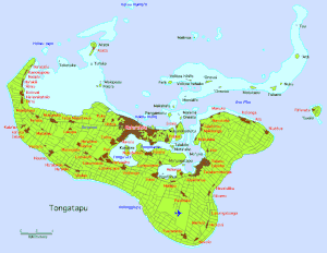
Nakolo ist ein Ort der Inselgruppe auf Tongatapu im Süden des pazifischen Königreichs Tonga.
| Nakolo | |||
|---|---|---|---|
| |||
| Koordinaten | 21° 16′ S, 175° 7′ W | ||
 | |||
| Basisdaten | |||
| Staat | Tonga | ||
|
Division |
Tongatapu | ||
| Distrikt | Tatakamotonga | ||
Nakolo hat 406 Einwohner (Stand 2016).[1]
Geographie
Der Ort liegt an der Südküste der Insel, östlich von Fuaʻamotu an der Liku Road. Er ist der südöstlichste Ort der Inselgruppe beim südlichsten Punkt der Insel Houma Toloa. Zwischen Fuaʻamotu und Nakolo befindet sich die höchste Erhebung von Tongatapu (65 m).[2]
Literatur
- A. H. Wood: History and Geography of Tonga, Wilton and Horton, Nukuʻalofa 1938.
Einzelnachweise
- Tonga 2016 Census of Population and Housing. (PDF; 9,14 MB) Volume 1: Basic tables and administrative report. Tonga Statistics Department, Oktober 2017, abgerufen am 22. Oktober 2020 (englisch).
- Fuaʻamotu bei GeoNames, geonames.org. Abgerufen am 21. Oktober 2020.
This article is issued from Wikipedia. The text is licensed under Creative Commons - Attribution - Sharealike. The authors of the article are listed here. Additional terms may apply for the media files, click on images to show image meta data.