Fuaʻamotu (Tongatapu)
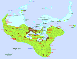
Fuaʻamotu (auch: Vai ko Latai, „Latai’s Wasser“) ist ein Ort der Inselgruppe auf Tongatapu im Süden des pazifischen Königreichs Tonga.
| Fuaʻamotu | |||
|---|---|---|---|
| |||
| Koordinaten | 21° 16′ S, 175° 8′ W | ||
 | |||
| Basisdaten | |||
| Staat | Tonga | ||
|
Division |
Tongatapu | ||
| Distrikt | Tatakamotonga | ||
| Einwohner | 1637 (2016) | ||
Fuaʻamotu hatte 2016 ca. 1637 Einwohner.[1]
Geographie
Der Ort liegt an der Südküste der Insel, südlich des Taliai Camp und westlich von Nakolo. Zwischen Fuaʻamotu und Nakolo befindet sich die höchste Erhebung von Tongatapu (65 m).[2]
Literatur
- A. H. Wood: History and Geography of Tonga, Wilton and Horton, Nukuʻalofa 1938.
Einzelnachweise
- Tonga 2016 Census of Population and Housing. Tonga Statistics Department, Oktober 2017, abgerufen am 21. Oktober 2020.
- Fuaʻamotu bei GeoNames, geonames.org. Abgerufen am 21. Oktober 2020.
This article is issued from Wikipedia. The text is licensed under Creative Commons - Attribution - Sharealike. The authors of the article are listed here. Additional terms may apply for the media files, click on images to show image meta data.