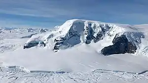
Mount Balfour
Mount Balfour ist ein 1010 m hoher, bollwerkähnlicher und felsiger Berg an der Fallières-Küste des Grahamlands im Norden der Antarktischen Halbinsel. Er ragt nahe der Mündung des Fleming-Gletschers in den Forster-Piedmont-Gletscher unweit der Nahtstelle zum Wordie-Schelfeis auf.
| Mount Balfour | ||
|---|---|---|
 | ||
| Höhe | 1010 m | |
| Lage | Grahamland, Antarktische Halbinsel | |
| Koordinaten | 69° 18′ 49″ S, 67° 12′ 12″ W | |
| ||
Teilnehmer der British Graham Land Expedition (1934–1937) unter der Leitung des australischen Polarforschers John Rymill nahmen 1936 eine grobe Kartierung vor. Der Falkland Islands Dependencies Survey kartierte ihn 1948 erneut und benannte ihn nach dem britischen Archäologen Henry Balfour (1863–1939), Präsident der Royal Geographical Society von 1936 bis 1938.
Weblinks
- Mount Balfour im Geographic Names Information System des United States Geological Survey (englisch)
- Mount Balfour auf geographic.org (englisch)
This article is issued from Wikipedia. The text is licensed under Creative Commons - Attribution - Sharealike. The authors of the article are listed here. Additional terms may apply for the media files, click on images to show image meta data.
