Motuokino Island
Motuokino Island, auch Shag Rock genannt, ist eine kleine Insel im Hauraki Gulf, im Norden der Nordinsel von Neuseeland.[1]
| Motuokino Island (Shag Rock) | ||
|---|---|---|
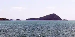 Motukaramea Island, Motuoruhi Island (von links nach rechts) | ||
| Gewässer | Hauraki Gulf | |
| Geographische Lage | 36° 45′ 3″ S, 175° 23′ 29″ O | |
| ||
| Länge | 135 m | |
| Breite | 90 m | |
| Fläche | 0,95 ha | |
| Höchste Erhebung | etwas über 40 m | |
| Einwohner | unbewohnt | |
Geographie
Motuokino Island befindet sich an der Westküste der Coromandel Peninsula[2], rund 9,35 km westlich von Coromandel. Zum Festland trennt die Insel rund 4,8 km in Nordost-Richtung, wovon ein Teil zum Hautapu Channel gehört. Die Insel besitzt eine Länge von rund 135 m in Ost-West-Richtung und eine maximale Breite von rund 90 m in Nord-Süd-Richtung. Sie kommt dabei auf eine Gesamtfläche von 0,95 Hektar und misst etwas über 40 m Höhe.[2]
Die nächstliegende Nachbarinsel Motuoruhi Island befindet sich rund 650 m in nordöstlicher Richtung und die im Verhältnis zu Motuokino Island nahezu gleich große Motukaramea Island liegt rund 1,06 km in ostnordöstlicher Richtung. Waimate Island, als größte Insel der Inselansammlung in dem Gebiet liegt knapp 2 km ostsüdöstlich entfernt.[2][3]
Einzelnachweise
- Topo maps. Land Information New Zealand, abgerufen am 21. Oktober 2020 (englisch).
- Motuokino Island (Shag Rock). In: NZ Topo Map. Gavin Harriss, abgerufen am 21. Oktober 2020 (englisch).
- Koordinaten und Längenbestimmungen wurden mittels Google Earth Pro Version 7.3.3.7721 am 21. Oktober 2020 vorgenommen