Morro Alto
Der Morro Alto („Hoher Hügel“) ist der höchste Berg der Azoreninsel Flores. Er liegt im Kreis Santa Cruz das Flores.
| Morro Alto | ||
|---|---|---|
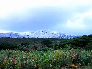
Blick auf den Morro Alto | ||
| Höhe | 914 m | |
| Lage | Flores, Azoren, Portugal | |
| Dominanz | 238 km → Cabeço Gordo[1] | |
| Schartenhöhe | 914 m | |
| Koordinaten | 39° 27′ 48″ N, 31° 13′ 13″ W | |
| ||
| Typ | Schichtvulkan | |
| Gestein | Basalt | |

Der Berg ist wie die gesamte Insel vulkanischen Ursprungs. Auf seinem Gipfel befindet sich seit 1986 ein Antennenmast.[2] Benachbarte Berge sind der Pico do Burrinha (886 m) und der Pico dos Sete Pés (849 m).
Der Morro Alto liegt im Ramsar-Gebiet Nr. 1806 Planalto Central das Flores (Morro Alto)[3] und im Natura-2000-Gebiet PTFLO0002 Zona Central – Morro Alto – Ilha das Flores.[4]
Weblinks
- Flores im Global Volcanism Program der Smithsonian Institution (englisch)
Einzelnachweise
- Flores High Point auf Peakbagger.com (englisch).
- Die Hochebene auf Flores, azoren-online.com, abgerufen am 22. August 2015.
- Planalto Central das Flores (Morro Alto), Ramsar Sites Information Service, 2008.
- Zona Central - Morro Alto - Ilha das Flores, Natura 2000 Standard Data Form, 2012.
This article is issued from Wikipedia. The text is licensed under Creative Commons - Attribution - Sharealike. The authors of the article are listed here. Additional terms may apply for the media files, click on images to show image meta data.