Mauliu
Mauliu ist eine osttimoresische Siedlung im Suco Tohumeta (Verwaltungsamt Laulara, Gemeinde Aileu).[1]
| Mauliu | |||
|---|---|---|---|
| |||
| Koordinaten | 8° 38′ S, 125° 33′ O | ||
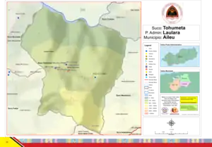 Karte des Sucos Tohumeta Karte des Sucos Tohumeta | |||
| Basisdaten | |||
| Staat | Osttimor | ||
| Aileu | |||
| Verwaltungsamt | Laulara | ||
| Suco | Tohumeta | ||
| Aldeia | Acadiro | ||
| Höhe | 577 m | ||
Der Weiler Mauliu liegt nah der Ostgrenze der Aldeia Acadiro zur Aldeia Tohumeta, auf einer Meereshöhe von 577 m. Einen halben Kilometer südlich befindet sich das Dorf Tohumeta, zu dem eine kleine Straße führt. Weiter nach Norden fällt das Land hinab zum Flusslauf des Bemos.[1]
Einzelnachweise
- Direcção-Geral de Estatística: Atlas der Gemeinde Aileu, abgerufen am 21. März 2021.
This article is issued from Wikipedia. The text is licensed under Creative Commons - Attribution - Sharealike. The authors of the article are listed here. Additional terms may apply for the media files, click on images to show image meta data.