Matapati
Matapati ist ein osttimoresischer Ort im Suco Madabeno (Verwaltungsamt Laulara, Gemeinde Aileu).[1]
| Matapati | |||
|---|---|---|---|
| |||
| Koordinaten | 8° 39′ S, 125° 34′ O | ||
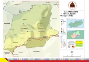 Karte des Sucos Madabeno Karte des Sucos Madabeno | |||
| Basisdaten | |||
| Staat | Osttimor | ||
| Aileu | |||
| Verwaltungsamt | Laulara | ||
| Suco | Madabeno | ||
| Aldeia | Remapati | ||
| Höhe | 1251 m | ||
Geographie
Das Dorf Matapati liegt im Norden der Aldeia Remapati auf einer Meereshöhe von 1251 m. Es teilt sich in die Ortsteile (Bairos) Remapati im Westen und Desmanhata im Osten. Die Überlandstraße von Aileu und Maubisse im Süden und der Landeshauptstadt Dili im Norden führt durch Matapati. Der Teil von Demanhata, der nördlich der Überlandstraße liegt, gehört zur Aldeia Desmanhata. Hier befindet sich auch der Sitz der Aldeia.[1]
Südwestlich liegt an der Überlandstraße das Dorf Belumhatu (Aldeia Belumhatu), östlich das Dorf Manehalo (Aldeia Manehalo). Eine kleine Straße führt nach Norden zu den Dörfern Malaeurhei (Aldeia Desmanhata), Madabeno (Aldeia Manufoni) und Lisimu (Aldeia Manehalo).[1]
Einzelnachweise
- Direcção-Geral de Estatística: Atlas der Gemeinde Aileu, abgerufen am 21. März 2021.